It’s unlikely you haven’t heard of the Silk Road – the famous trade network where people have exchanged goods and knowledge for centuries. The term is, in fact, a reference to a large and dynamic trade network as opposed to a single road.
If you’re a history nerd, the idea of exploring an ancient route that had a major impact on global events may sound appealing. To help you do so, I’ll first explain what the Silk Road is all about and then propose a long and original (to be best of my knowledge) trip itinerary that will take you to several famous locations that were once part of the famous trade network.
Part 1: Understanding the Silk Road
Why do we call it the Silk Road?
Are you confused about the idea of planning a trip to the Silk Road since it’s not really a road? Worry not, it will soon become clear why this term exists and what trade networks are the most likely to be referenced by it.
The Silk Road is a generic term meant to refer to the large network of ancient trade routes extending from East and Southeast Asia through the Indian subcontinent, Persia, the Arabian Peninsula, East Africa, and Southern Europe.
The term “Silk Road” was not used when people were trading on the routes. According to many sources, it was the German geographer Ferdinand von Richthofen who invented the “silk road” concept. But was Richthofen genuinely the first to use “the Silk Road” in its singular or plural forms? Maybe not.

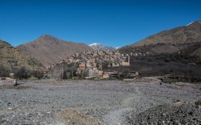
Silk trading routes between China and India
While Richthofen played a key role in refining and popularizing the “silk road” idea within academic circles, it may have not been its sole creator. Before him, academics like Robert Mack, Hermann Guthe, and Johann Kaeuffer had already used it. Richthofen was merely a part of a larger continuum that elevated the term “Seidenstrasse” (The German word for “silk road”) from academic circles to global recognition. He gave it a clear definition, unified the idea under one label, and initiated its translation into various languages.
Another German geographer, Carl Ritter, may have been the first to use the term “silk road”, in his works on trans – Eurasian relationships. Given that his works were inspired by other works on the same topic, it is unclear whether the term was not taken or at least inspired by other words. The main point is, that the development of the concept may not be the merits of a single person but the result of an evolution of concepts and terminology across scholars, languages, and geopolitical lines.
So now you know. We call it the Silk Road because a bunch of 19th-century geographers used the term for Euro-Asian trade networks where silk played a significant importance. Now it’s time to find out more about the impact of the Silk Road on human civilization.
How has the Silk Road changed the world?
While not a single road, the trade networks referred to as the Silk Road are one of the first cultural “corridors” to be inscribed on the World Heritage List. It is easy to see why UNESCO decided to do so. The Silk Road was a place where different cultural groups exchanged architectural concepts, wall paintings, music art, dance, and theatric performances, among others.
Geographically, the Silk Road connected the eastern and western extremities of the Eurasian continent. It traversed China, Kazakhstan, Kyrgyzstan, Tajikistan, Turkmenistan, and Uzbekistan. The route also included parts of Korea and Japan in the east, Russia and Europe in the west, and India and the Middle East towards the south and southwest.
In other words, the Silk Road was by no means a primary channel for transporting Chinese silk westwards. Rome, the Byzantine Empire, India, Iran, the Arab Caliphate, Russia, and some European nations exported various products to China as well. Besides silk, goods being traded included frankincense, myrrh, amber, cardamom, nutmeg, jasmine, a ginseng. The network was also used to exchange textiles, minerals, precious stones like diamonds and jade, gold and silver bullions, and myriad weaponry. Animal species were also traded on the network, including Fergana horses, lions, camels, elephants, and rhinoceros.
As mentioned before, the Silk Road was also a place where different groups exchanged culture and knowledge. For instance, the trade network appears to have played an important role in bringing prominence to the Timurid style in ceramics, which is recognized by its unique blue shade painted on a white canvas. Originating in the workshops of the emperor in China during the time of the Yuan dynasty (1279-1369), this style gained popularity in areas such as Iran, Turkey, and Central Asia. Presently, ceramic bowls and vases reflecting this style are displayed in global museums.
Another aspect showcasing the Silk Road’s artistic influence is seen in the “Baghdad painting” style. This style decorated the walls of sanctuaries in areas like Kostobe and the Talas valley, associated with Jammukat/Hammukat. Detailed designs featuring grape withers, tulip patterns, rosettes, palmettes, and a variety of plant bouquets graced these panels. Similar design elements are visible on palace walls in places such as Afrasiyab, Varakshi, Samarra, and Fustat.
Documents from history highlight the diverse cultural performances that were a hallmark of the Silk Road. For example, the most revered music in Tang China was influenced by distant lands, with roots in cities like Eastern Turkestan and Central Asia. This led to a blending of musical styles from regions like Kuchi, Kashghar, Bukhara, and Samarkand with traditional Chinese melodies.
Movable type and paper were technologies that journeyed westward, with their most effective combination occurring in Europe. Medical insights, frequently from Islamic origins, were exchanged as well. Among these, inoculation was a significant shared concept. The Silk Road perpetually disseminated military technologies as well, ranging from stirrups to siege instruments. Gunpowder, transferred through Mongol invasions, was the most obvious military exchange.
The Silk Road also influenced the spread of religious beliefs and practices. For instance, Buddhism made its way from India to Central Asia and East Turkestan via the Silk Road. Similarly, Christianity, followed by Islam, spread from regions like Syria, Iran, and Arabia through this ancient route.
Part 2: Exploring the Silk Road
Now that you have a basic understanding of the Silk Road as a concept and the history of the trade network, you are better equipped to choose a travel itinerary that will take you to destinations you find interesting.
The itinerary I’m proposing will take you from Western Europe to Eastern Asia and can be altered according to your needs and possibilities. If you would rather do your own itinerary, check out this Silk Road interactive map so you know what the main locations on the trade network are.
Without further ado, here’s an itinerary that will take you to multiple countries and weeks to complete.
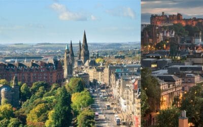
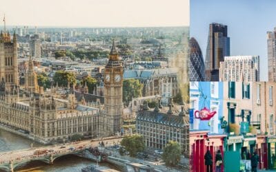
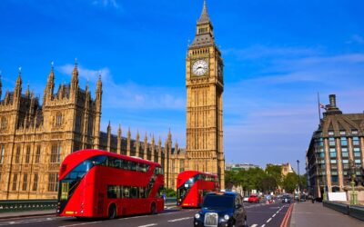
Welcome to London
Surprising, I know. While London is not part of the Silk Road, you have to start somewhere. And if you don’t want to start from London, then so be it – there are plenty of ways to reach Istanbul.
You will want to start in London if you live there or if you want to cross Europe by train before reaching one of the silk routes. The exact train connections available will not always be the same, so make sure to plan your trip in advance and book train or bus tickets carefully.
Eurotrip from London – Istambul
To get from London to the mainland, you will typically use Eurostar, going from London St Pancras International to Paris Gare du Nord. This train journey will take just about 2 hours and 15 minutes.
From Paris, you can head towards Munich or Vienna. A direct train from Paris to Munich will take around 7 hours. At the time of writing this, there are no direct trains from Paris to Vienna and it will take you around 10 hours to reach the capital of Austria. While the journey is slightly longer than the one taking you to Munich, note that it is significantly more scenic, as you are crossing the Alps.
From Munich or Wien, you can take a train or a bus to Budapest. If you start in Munich, you will need around 7 hours to reach the capital of Hungary and you will have to change the train in Vienna. A direct connection will take you from Wien to Budapest in 2 hours and a half.
From Budapest, you will take a train connection to Bucharest. At the time of writing this, large chunks of the route from Budapest to Bucharest are being upgraded, making the journey last 16 hours. If you do book a train on this route, make sure to find one that passes through Brasov, Transylvania, as this will give you the chance to one of Europe’s picturesque regions.
To get from Bucharest to Istanbul, you will need to spend at least 20 hours on a train that will take you from Southern Romania to Bulgaria. If you travel between June and October, you will have access to a direct couchette car from Bucharest to the capital of Turkey. If not, you will have to travel from Bucharest to Sofia or to Dimitrovgrad, in Bulgaria, to then join the sleepers or couchettes of the Sofia-Istanbul Express.
After approximately 3 days, you will finally reach Istanbul and get ready to embark on the Silk Road. Now, should you go from London to Istanbul on a train knowing that you will be extending your overall trip by at least 3 days? That’s up to you. If you want your journey to be as long as possible or to combine a trip on the Silk Road with a Eurotrip, then the answer is yes.
Going from London to Istanbul by train will take you through at least eight countries, alpine landscapes, and some of the world’s most famous cities. Trains are arguably the best means of transportation for this type of journey and you can save money by purchasing an Interrail or Eurail Pass.
Explore Istanbul
Istanbul is a city that’s literally at the crossroads of two continents – Europe and Asia. The Bosphorus is the strait that not only separates these two land masses but also connects the Black Sea to the Sea of Marmara.
The city was originally known as Byzantion, a name of Thracian or Illyrian origin, and was established by Greek settlers from Megara in around 660 BCE. It was later named Byzantium and became part of the Roman Republic in 196 BCE. Following the reign of Emperor Constantine, the Great who refounded it as Constantinople in 330 CE, the city became the new capital of the Roman Empire. It was the largest city in the western world under Justinian I, with a peak population close to half a million. The city fell to the Ottoman Turks in 1453 and was renamed Istanbul, serving as the capital of the Ottoman Empire until the establishment of the Republic of Turkey in 19231. During the Ottoman period, the city regained its status as one of the world’s most populous cities with a population of around 700,000 in the 16th century.
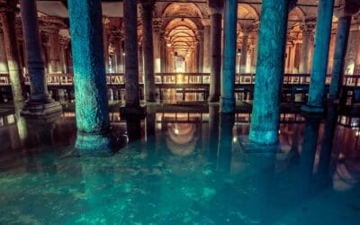
For most people, Istanbul is not the type of city where you spend a few hours and then you want to leave. If you are not going to make your journey very long, you should focus on seeing some of the most important attractions of the city. The list of top things to see include the Hagia Sophia Grand Mosque, the Blue Mosque, the former residence of the Ottoman sultans (Topkapi Palace), the Byzantine cisterns (e.g., Basilica Cistern, Serefiye Cistern), the Topkapi Palace, and the Dolmabahçe Palace. I also recommend a Bosphorus boat tour.
Welcome to Ephesus.
You are finally on the Silk Road! The ancient city of Ephesus feels like stepping back into ancient times. It was the Roman Empire’s second-biggest city right after Rome itself. An interesting fact to know is that they’ve only unearthed about 20% of the city after 150 years of digging. In other words, there’s still a lot of the city waiting to be discovered.
While there, you will find the Temple of Artemis, a massive structure that was one of the Seven Wonders of the Ancient World. Although it’s mostly rubble now, it used to be an epic temple with huge columns that took over a century to build. A fire in the 4th century B.C. destroyed the temple and it was actually rebuilt before it fell into ruins again1.
Ephesus is a UNESCO site because it has some of the best-preserved Roman ruins around. The city is also the place where a huge library, the Library of Celsus, was built to honor a Roman governor. It was earthquake-proofed by Tiberius, the Roman Emperor, and was home to thousands of scrolls.

Ancient stone bridge in Turkey on an historical Silk Road route
To get from Istanbul to Ephesus, you’ve got a few options. The most budget-friendly way is by bus, which will take about 8-10 hours and set you back around €30. You’d take the bus to Selçuk, and from there, it’s a short dolmuş ride to Ephesus.
Alternatively, you can fly to Izmir Adnan Menderes Airport, which is the closest to Ephesus. Turkish Airlines and Pegasus Airlines offer direct flights from Istanbul that take roughly 1 hour and 10 minutes. Pegasus is typically cheaper, with prices starting at about €35. Finally, there are full-day guided tours from Istanbul that’ll sort everything out for you.
Ephesus to Konya
To journey from Ephesus to Konya, you will likely embark on a road trip or take a bus, as these cities are approximately 550 km (371 mi) apart, a journey that can take around 7 to 8 hours by road. The route takes you through the scenic heart of Turkey, passing through valleys and mountains, and along the way, you will transition from the Greek and Roman influences of the coast to the more Persian and Islamic influences of central Anatolia
Konya is one of the oldest cities in the world with a history that dates back to the 3rd millennium BCE. It gained prominence during the Roman era and became an important center for the early Christians. The city is perhaps most famous for its association with the Sufi mystic Rumi and the Mevlevi order of dervishes, known for their whirling ceremonies.
While in the city, you can visit the Mevlana Museum, formerly the lodge of the Whirling Dervishes. There you will find the mausoleum of Jalal ad-Din Muhammad Rumi, a Sufi mystic also known as Mevlana or Rumi.
Another significant site is the Selimiye Mosque, an Ottoman-era Mosque commissioned by Sultan Selim II and designed by the renowned architect Mimar Sinan. The Alaeddin Mosque, which sits atop the Alaeddin Hill, is another important historical and religious site, built on the foundations of earlier Byzantine and Seljuk structures.
You can also visit the Konya Archaeological, which houses a collection that spans the Neolithic Age to the Byzantine period, including coins, icons, and examples of Seljuk ceramics and bronzes. Finally, you can check out the Karatay Medrese, now also a museum, which showcases stunning examples of Seljuk tile work.
Konya to Cappadocia
You can cross the 236.4 km (147 m) distance between Konya and Cappadocia by bus, taxi, or car. The bus is both the cheapest and the quickest option, with services operated by Kamil Koc running hourly from Konya bus station to Göreme bus station. The journey takes approximately 3 hours and 15 minutes, costing between 470 and 650 Turkish Lira. Alternatively, MetroTurizm also services this route once daily.
Upon reaching Cappadocia, will find a landscape that has captivated travelers for centuries. Known for its distinctive fairy chimneys, rock-hewn churches, and ancient underground cities, Cappadocia’s history and landscapes are quite interesting. The Hittites, Romans, and Seljuks have all left their marks here.
To many, the best thing you can do in Cappadocia is a sunrise hot air balloon ride. In addition, you can explore the underground cities, visit the Uchisar Castle, hike through the Red Valley, do a sunset ATV tour, or visit the Göreme Open-Air Museum, which has some of the most well-preserved frescoes in the world within its rock-cut churches
Cappadocia to Batumi
To reach Batumi from Cappadocia, one typically has to navigate a combination of road and air travel. The distance between Cappadocia and Batumi is approximately 915 kilometers (568 miles). The most common route involves driving to Kayseri, which is about 75 kilometers (47 miles) from Cappadocia, and then taking a direct flight to Batumi. The flight from Kayseri to Batumi takes around 1 hour and 30 minutes, but this doesn’t account for the transit time to and from airports and any waiting times for the flight. Alternatively, if one chooses to drive the entire distance, the journey could take upwards of 14 hours, assuming you don’t stop anywhere on your way.
Upon reaching Batumi, you step into a city purported to be located on the site of one of the ancient Greek colonies on the coast of Colchis. Known historically as Bathus Limen, meaning “deep harbor,” Batumi has been a strategic port throughout history, with settlement evidence dating back to the 8th-7th century BC. It was even home to a Roman military fort during the reign of Emperor Hadrian. In the medieval period, Batumi was scarcely mentioned in contemporary sources but reemerged in both Georgian and European accounts in the 15th century. It later fell under Ottoman control, which led to the Islamization of the region by the end of the 18th century and the city’s development as a vibrant port but also the center of the Caucasian slave trade.
Modern-day Batumi offers attractions like the Batumi Boulevard, a waterfront promenade dotted with modern art and a variety of cafes; the Batumi Botanical Garden, which has one of the largest collections of flora in the former Soviet Union; and the Adjara State Museum, which comes with a collection of local historical artifacts. You can also explore the Batumi Dolphinarium or enjoy some nice views from the Batumi Cable Car.
Batumi to Svaneti
Traveling from Batumi to the Svaneti region in Georgia is a journey into a landscape dominated by mountains and deep gorges. You can get to Svaneti by taking a bus or a marshrutka (a type of minibus) from Batumi’s bus station to Zugdidi, and then another marshrutka from Zugdidi to Mestia, the central town of the Upper Svaneti region. This trip can take approximately 5-6 hours from Batumi to Zugdidi and another 3-4 hours from Zugdidi to Mestia, depending on road conditions and weather.
Svaneti’s history dates back to ancient times when the province was a dependency of the kingdom of Colchis and later Lazica. Throughout the centuries, Svaneti was coveted for its strategic importance, eventually becoming a duchy within the Kingdom of Georgia during its golden age under Queen Tamar in the 12th century. The region remained largely inaccessible, which protected it from the Mongol invasions.
The landscape of Svaneti is characterized by its coniferous and mixed forests, as well as alpine meadows and grasslands. The region is known for its heavy snowfall, with snow cover and avalanches being frequent occurrences.
While in the city, you can visit the Svanetian tower houses built between the 9th and 12th centuries. These unique structures contribute to the picturesque villages of the region, making places like the community of Ushguli in Upper Svaneti a UNESCO World Heritage Site. The region is also famous for its polyphonic singing, a cultural tradition that features loud, dissonant chords connected to round dances.
Svaneti to Kutaisi
The distance between Svaneti and Kutaisi is about 82 km (51 mi), with a road distance of 175.4 km (109 mi). To travel from Svaneti to Kutaisi, you have three main options. The recommended way is by minibus, which takes about 6 hours and 30 minutes and costs between $17 and $18. Alternatively, a taxi can make the trip in approximately 4 hours and 39 minutes, but it will cost significantly more, ranging from $55 to $70. Driving is also an option and takes the same amount of time as a taxi, but costs between $21 and $35 for the journey.
Kutaisi is also one of the oldest continuously inhabited cities in the world and has been a significant cultural and political center for Georgia through the ages. Its roots extend to the Lower Paleolithic period, and it served as the capital of Georgia from the 8th century BCE until the 11th century.
The city’s attractions include the garden boulevard leading to the central square, known as the “Parliament of Kutaisi”. Another well-known spot in the city is the Colchis fountain, which is adorned with representations of golden figures from the Vani excavations. Historical monuments such as the residence of the Imeretian king and the Bagrati Cathedral, which dates back to 1003, and also places you might want to visit. Other landmarks include the Kutaisi Drama Theatre, designated as a national cultural monument, and the Kutaisi Opera and Ballet Theatre, adorned with Roman figures by a local sculptor.
At a distance of about 6 km (3.7 mi) northeast of the city, you can find the Gelati Monastery Complex, a UNESCO World Heritage site, and the Motsameta Monastery. The Gelati Monastery was established in 1106 and showcases smooth, finely-cut blocks, balanced proportions, and ornamental blind arches.
Kutaisi to Gori
You can travel from Kutaisi to Gori by train, which takes approximately 3 hours and 55 minutes and costs between $2 and $10. Alternatively, you can take a taxi from Kutaisi to Gori with a travel time of about 2 hours and 9 minutes at a cost between $50 and $65. For those who prefer to drive, the journey also takes around 2 hours and 9 minutes. The distance between Kutaisi and Gori is about 121 kilometers (75 miles), with the road distance being 153.7 kilometers (95.5 miles).
Gori, the seventh-largest city in Georgia and the administrative capital of the Shida Kartli region has been an important waypoint on east-west trading routes, including the Silk Road, for centuries. Gori’s name comes from the Georgian word ‘gora,’ meaning ‘heap’ or ‘hill,’ inspired by the flat-topped sandstone hill at the city’s center. Gori Fortress, a medieval military stronghold, is one of the city’s most distinctive landmarks.
The city is small enough that most attractions can be explored on foot. Gori’s old town, particularly around Kristopher Castel Street and Akaki Tsereteli Street, features heritage architecture with pretty houses and brick buildings. Intricate patterns in the brickwork, aged wooden doors, and Georgian-style latticed balconies are typical architectural features of the area.
Gori to Uplistsikhe and Tbilisi
Traveling from Gori to Uplistsikhe covers a distance of approximately 6.4 km (4 mi), easily traversed by a 12-minute taxi ride. Uplistsikhe is one of Georgia’s oldest urban settlements, having been founded in the late 2nd millennium BC.
This ancient town used to be an important political and religious center in the kingdom of Kartli. Today, it is home to significant structures such as a pillared hall and a 6th-century basilica. Despite its decline following the 14th-century Mongol raids, Uplistsikhe is still quite an interesting place to visit.
From Uplistsikhe, various transport options are available to Tbilisi, including a 58-minute train journey, a 1-hour 42-minute minibus ride, or a similar duration by taxi or car. Tbilisi, the present-day capital of Georgia, was founded in the 5th century by King Vakhtang Gorgasali and rapidly evolved into a key trade hub along the Silk Road.
The city’s key landmarks include the Old Town (Altstadt), Tsminda Sameba Cathedral, the Bridge of Peace, the historic Narikala Fortress, and Rustaveli Avenue, lined with cultural institutions. Other notable sites include Metekhi Cathedral, the Memorial History of Georgia, Sioni Cathedral Church, Mtatsminda Pantheon, and the Anchiskhati Basilica.
Old Tbilisi, the historical part of Tbilisi, encompasses districts such as Abanotubani, Avlabari, Sololaki, and others. Old Tbilisi’s architecture includes sulfur baths, churches, museums, and houses with wooden carved balconies. The city of Kala within Old Tbilisi had a royal residence, palaces, churches, baths, and an observatory.
Tsminda Sameba Cathedral was built in 2004 and includes a complex with a residence for the Patriarch, a monastery, a school of theology, an academy, and a hotel. At 101 m (331 ft), it is the highest church in Georgia.
The Bridge of Peace is a bow-shaped pedestrian bridge designed by Italian architect Michele De Lucchi that spans 150 m (492 ft) over the Kura River. It’s a steel and glass construction with LED illumination, connecting Rike Park with the Old town
The Narikala Fortress consists of two walled sections with a restored St Nicholas church. The fortress’s earliest sections date back to the 4th millennium BC. According to legend, the fortress was built by King Vakhtang I Gorgasali.
The Sioni Cathedral of the Dormition, it’s a Georgian Orthodox cathedral in Tbilisi, named after Mount Zion at Jerusalem. Located in downtown Tbilisi, it was initially built in the 6th and 7th centuries and has undergone multiple reconstructions, with the current structure reflecting the 13th-century version with some modifications from the 17th to 19th centuries.
The Anchiskhati Basilica is the oldest surviving church in Tbilisi, dating from the sixth century and belonging to the Georgian Orthodox Church. It was originally built by King Dachi of Iberia and dedicated to the Virgin Mary. The basilica was renamed Anchiskhati in 1675 after a treasured icon was moved to Tbilisi to preserve it from an Ottoman invasion. The basilica has been damaged and rebuilt several times due to wars, with significant changes made in the 1870s and during the Soviet period.
Tbilisi to Telavi
You can travel from Tbilisi to Telavi on a taxi from Isani for approximately $6.60 per person or with a marshrutka from Navtlughi Bus Terminal or Ortachala Bus Station. At Ortachala, taking a taxi from Liberty Square costs around $2.64. The bus ticket to Telavi ranges from $3.96 to $4.95, with 13 scheduled vans departing daily between 7.30 am and 6.20 pm. The journey takes about 2 hours via the Gombori Pass for taxis and 3 hours via the Kakheti Highway for marshrutkas.
Telavi, nestled in the Gombori Mountains against the Greater Caucasus, is the largest city in Georgia’s eastern Kakheti region. Telavi flourished in the 17th century as a cultural, religious, and winemaking center. Key attractions include the Batonis Tsikhe Fortress (a 17th-century structure with ramparts, towers, ornate gates, arched portals, and a Persianate-style design), the Telavi History Museum, the Giant Plane Tree (a 900-year-old tree with a circumference of 12 m/39 ft, considered the oldest living tree in the country), and streets lined with traditional Kakhetian carved balconies. Telavi’s artisanal heritage is showcased in its craftsmanship, with notable pottery. It’s also a good base for exploring nearby vineyards and important monasteries in the region.
Telavi to Dilijan
Traveling from Telavi to Dilijan can be done by bus or car. The bus journey takes around 5 hours and 6 minutes, with tickets costing between $12 to $25. Alternatively, going from Tbilisi to Dilijan with a taxi will allow you to cover a distance of 182.1 km (113 mi) in about 2 hours and 45 minutes, with the cost ranging from $22 to $35. There is no direct bus from Tbilisi to Dilijan, but services are available with a change at Tbilisi Avlabari Station.
Dilijan, known as the “Little Switzerland of Armenia,” is a resort town known for its landscape beauty and artisan traditions. The town is located in the heart of Dilijan National Park and is surrounded by forested mountains and alpine meadows.
Initially known as Hovk, the area was part of the historic Greater Armenia. Archaeological excavations in the 1870s unearthed valuable items from the late Bronze and early Iron ages. Monasteries like Haghartsin and Goshavank, built between the 10th and 13th centuries, turned Dilijan into a significant cultural and educational hub.
Key attractions include Old Dilijan with its cobbled street and traditional stone buildings, the Geological Museum and Art Gallery, and the Haghartsin and Goshavank Monasteries. The town can serve as a base for outdoor activities from May through September and for snow sports during winter.
Dilijan to Lake Sevan and then on to Yerevan
A trip from Dilijan to Lake Sevan is a short one, covering a distance of only about 37 km (23 mi). You can travel by taxi or bus. A taxi ride takes approximately 33 minutes while a bus ride will take much longer, about 3 hours and 10 minutes. The estimated cost for a taxi ranges from $11 to $14. If opting for the bus, expect to pay between $3 and $5 for the trip.
Lake Sevan, set at over 1925 m (6315 ft) above sea level, is one of Armenia’s key tourist attractions. The area is known for its historic sites like the Hayravank Monastery, a building dating back to the 9th-12th centuries.
Traveling to Yerevan from Lake Sevan, located about 65 km (40 miles) away, is convenient by marshrutka minivans or taxis. The marshrutka ride from Lake Sevan to Yerevan takes just over an hour and is the more interesting option. The cost for the marshrutka is around 800 AMD (approximately $1.70). Taxi fares will vary and, like always, it’s best to ask in advance.
Yerevan is the capital of Armenia and was founded as the fortress of Erebuni in 782 BC by King Argishti I of Urartu. Throughout its history, Yerevan has witnessed the rise and fall of several empires, having been under the rule of Romans, Parthians, Arabs, Mongols, Turks, Persians, Georgians, and Russians. In the modern era, Yerevan became the capital of the First Republic of Armenia in 1918 and later the Armenian Soviet Socialist Republic in 1920.
Notable landmarks include the Cascade Complex, the Republic Square, Saint Gregory Cathedral, Tsitsernakaberd, the Armenian Genocide memorial, and the Erebuni Fortress.
The Cascade Complex is a giant limestone stairway adorned with fountains and modernist sculptures. It connects the city center with a higher residential area and offers nice views of the city and of Mount Ararat.
As you might suspect, Republic Square is the main square of the city and was designed by the Armenian architect Alexander Tamanyan in 1924, with most of the surrounding buildings completed by the 1950s. The National Gallery, the last building to be completed, was finished in 1977. This square is characterized by its expansive open space and is surrounded by significant buildings, including the Government House, the History Museum of Armenia, the National Gallery, Government House #2, the Post Office Building, and the Armenia Marriott Hotel. These buildings, designed with a unique blend of Soviet-era architecture and modernist design, are mostly built from pink and yellow tuff stones, featuring arches, columns, and national ornaments.
Saint Gregory the Illuminator Cathedral in Yerevan, Armenia, is the largest cathedral of the Armenian Apostolic Church in the world. Situated in the Kentron District of Yerevan, the building stands at a height of 54 meters (174 ft), covering an area of 3,822 sq m (12,539 sq ft).
Tsitsernakaberd, the Armenian Genocide Memorial was erected in 1967 and encompasses several key elements that symbolize the tragic events. One of the most significant parts of Tsitsernakaberd is the Armenian Genocide Museum-Institute, established in 1995. The museum houses several historical documents, photographs, and personal belongings of the genocide victims and offers guided tours in several languages.
Erebuni Fortress is an ancient Urartian fortified city dating back to 782 BCE. It was founded by Urartian King Argishti I as a military stronghold to protect the kingdom’s northern borders. The fortress, strategically built atop the Arin Berd hill, overlooks the Ararat plain and once played a significant role in the region’s defense and administration. Architecturally, the Erebuni Fortress was designed with several key components, including a temple dedicated to the Urartian god Khaldi, a royal palace, administrative offices, residential homes, and commercial buildings. Throughout its history, the fortress served as a residence and military base for successive Urartian kings, particularly during their campaigns against northern invaders.
Yerevan to Tatev
The distance between Yerevan and Tatev is approximately 256 km (160 mi), and it typically takes around 4.5 to 5 hours by car. There are no direct minibusses from Yerevan to Tatev. You must take a minibus to Goris, and then a taxi to Halidzor to board the cable car to Tatev. The journey from Yerevan to Goris takes about 4-4.5 hours and costs around 2,500-3,000 AMD (approximately $5-$6). From Goris, a taxi to Halidzor costs about 2,200 AMD (around $4) one-way. A direct taxi from Yerevan to Tatev costs about 25,000 AMD (approximately $50). If you can go on a shared taxi, expect to pay between 4,500-6,000 AMD per person (about $9-$12).
Tatev Monastery dates from the 9th century and was a major manuscript production site. The “Wings of Tatev” is a record-breaking aerial cableway providing a scenic route to the monastery. The cable car operates from Tuesday to Sunday and is closed on Mondays. Ticket prices vary by season, with a round trip costing about 7,000 AMD ($17). Other attractions on the route to the monastery include the Noravank Monastery, the 19-meter-high Shaki Waterfall, and the boulders-rich archeological site known as Zorats Karer.
Tatev to Sheki
Tatev is your last stop in Armenia, as Sheki is located in Azerbaijan. There’s a considerable distance between the two locations – around 446 km (277 mi). As such, if you were to travel by car, strongly unadvisable at the present time, you can expect to travel around 8.5 hours by car, depending on road conditions and average speed.
Security Alert: At the time of writing this (January 17th, 2024), there is the potential for armed conflict near the Armenia-Azerbaijan border for which you should avoid the area. If you happen to be in the area, exercise caution on roads near the border and keep in mind that some portions of the road may cross international boundaries without notice. The reason for this is a dispute over an area known as Nagorno-Karabakh remains unresolved. While a ceasefire exists, the eastern border between the two countries is closed. In addition, the border areas also contain mines and unexploded weapons.
Due to this situation, the best way to cross from one country to the other is by plane. For that, you will need to return to Yerevan and take a direct plane from Armenia’s capital to Baku, Azerbaijan. From Baku, you can then take a bus to Sheki. The bus from Baku to Sheki runs daily every 2 hours from 9 AM to 11:50 PM, taking approximately 6 hours to complete the journey. The bus ticket costs around 8.4 AZN per person ($5).
Sheki is an 18th-century town, which by the 19th century, became the main center of silk production in the Caucasus region. The city has a deep-rooted history in silk weaving, which continues to be a part of its industry. The town also served as the capital of the Khanate of Sheki, which was annexed by Russia under the. The Khan’s Palace or Palace of the Sheki Khans, a summer residence renowned for its intricate murals and colors, is a UNESCO World Heritage Site.
A stop in Baku
Baku is located on the western shore of the Caspian Sea. The first historical references of the city date back to 885 CE but settlements existed since much earlier. The city came under various rules, including the Shirvanshahs in the 12th century, the Mongols in the 13th and 14th centuries, and later the Russian Empire in the early 19th century.
The heart of Baku is, as it’s typically the case, the Old City, or Icherisheher, a UNESCO World Heritage Site known for its historic sandstone buildings and maze of narrow alleys. Landmarks include the Palace of the Shirvanshahs, Maiden Tower, and Muhammad Mosque. The Palace of the Shirvanshahs is a historic landmark built over several centuries, serving as the seat of power for northeastern Azerbaijan’s ruling family during the Middle Ages. The palace complex includes burial vaults, mausoleums, gates, bathhouses, and a mosque. The Maiden Tower is a structure with a history that is rather shrouded in mystery, believed to be a Zoroastrian fire temple initially. Today, it houses a museum and offers panoramic views of the Old City. The Muhammad Mosque, also known as the Siniggala Mosque for the name of its minaret – Siniggala (“damaged tower”), dates from the 11th century and it is considered to be the first building in Azerbaijan connected to Islam.
Sheki to Lahich
Traveling from Sheki to Lahich in Azerbaijan involves a journey of approximately 176 km (about 109 mi), and it typically takes around 3.5 hours by car. If you decide to go with a taxi, you can expect to pay around $70.
Lahich is only a village that used to be an important center for craftsmen during the medieval period. The village is known for its copper work and production of arms and copper items decorated with carved ornaments. This tradition led to the development of various related professions, including tinsmiths, blacksmiths, carpenters, and more.
The cultural output of Lahich is well-represented in various museums around the world, including collections of copperware; not bad for a village. The copper craftsmanship of the village has gained so much reputation that, in 2015, was included in UNESCO’s Representative List of the Intangible Cultural Heritage of Humanity.
Baku to Turkmenbashi
Turkmenistan is one of the world’s craziest dictatorships and all travelers need to secure a visa in advance. The process can be complex and typically requires a certified letter of invitation from a host in Turkmenistan. This invitation is usually arranged through a travel agency, and you must also register with the State Migration Service upon arrival. Anyone on a tourist visa in Turkmenistan must have a guide who is responsible for them. In Ashgabat, the capital, the guide doesn’t need to be physically with you, however outside of Ashgabat your guide must accompany you.
Traveling from Baku to Turkmenbashi, Turkmenistan, across the Caspian Sea is quite an experience; especially since there’s a lack of a fixed ferry schedule. The journey can be unpredictable and the outcomes are influenced by several factors, including weather conditions and cargo priorities.
The reason for this unpredictability is that the ferries that operate on this route mostly serve as cargo vessels, but, lucky for you, they also welcome passengers. The crossing will offer you nice views of the Turkmen and Azeri coasts and probably beautiful sunsets. Sounds like a cool trip, right?
If this doesn’t sound adventurous enough, worry not. These cargo vessels don’t sell tickets only and you will have to purchase them at the port. For the latest information on ferry departures, you can contact the ticket office at Alat Port. It’s recommended to call between 10:00-11:00 for updates on boat departures.
The port of departure in Azerbaijan is Alat Port, located around 74 km (46 mi) from Baku. A taxi from Baku to Alat should cost around $40, and there is also a bus option available, but the last stop is about 2 km (1.2. mi) away from the port.
Since the ferry services lack a fixed schedule and can be delayed, it’s advisable to have sufficient food, water, and other essential supplies for the duration of the journey. The ferries have basic facilities, including toilets and, unfortunately for those who want to experience even less comfort, a small café.
The ferry will take you to Turkmenbashi, a port city in Turkmenistan on the eastern shore of the Caspian Sea. The city used to be known as Krasnovodsk and was first founded in 1717 as a Russian fort, and later reestablished in 1869, after having been abandoned for a century. The city served as a base against regional khanates and for controlling the nomadic Turkmen tribes. The development of Krasnovodsk was closely linked to the construction of the Trans-Caspian Railway, making it a vital commercial and transportation hub.
The city is home to Turkmenistan’s largest seaport, an important center for maritime activities on the Caspian Sea, and includes several historic buildings and quarters that showcase architecture with Caucasian features, somewhat similar to that of Baku.
Desert trekking around Turkmenistan
From Turkmenbashi, you will go to Yangykala Canyon, a journey that takes around 2.5 by car. Since it’s a rough terrain, it is best to use a 4×4 vehicle. You may or may not like that the canyons are in a remote area with no settlements nearby.
The canyon, known for its stunning red and yellow rock formations, was formed about 5.5 million years ago and extends for about 25 kilometers towards the Garagogazgol basin. Its cliffs are characterized by what many would call dramatic colors and formations, including the iconic ‘Crocodile’s Mouth’. Visitors are advised not to venture into the lower parts of the canyon due to safety risks.
Note that the route to the canyon is desolate with endless horizons, and it’s easy to get lost. As such, make sure you have an experienced off-road driver and be well-prepared with spare petrol and water.
Your next stop is Melegoch, a destination that you will reach by driving 180 km (111 mi). Once in Melegoch, you will find yourself in another desert area which also has dunes. During the daytime, you can explore the ancient necropolis of Melegoch, which is located about 1 km (0.6 mi) from the settlement. If that’s not your thing, worry not, as there’s plenty of landscape to explore in the area, including multi-colored mountains, extensive saline hollows, and rugged cliffs. At night, you can camp in the dunes and enjoy a pretty night skyline.
For more on this topic, check out our guide on how to trek the Karakum Desert & see the Darvaza Gas Crater.
Explore Ashgabat
Ashgabat, the capital of Turkmenistan, is a city of contrasts. Known as the ‘City of White Marble,’ Ashgabat holds a Guinness World Record for the highest density of white marble-clad buildings, which gives it an original appearance. The city also houses artifacts from the Parthian and Persian Empires. If you are a history enthusiast, key hotspots for you might be the Ashgabat National Museum of History and the Parthian Fortresses of Nisa – an UNESCO World Heritage Site that was once a major city in the Parthian Empire.
The city experiences a desert climate with hot, dry summers and mild winters. The ideal times to visit are during the spring (March to May) and autumn (September to November) when the weather is pleasant.
Ashgabat to the Darvaza Gas Crater
The journey from Ashgabat to the crater takes approximately 3.5 hours each way. One of your transportation options is a bus ride to Darvaza station, which takes about 3 hours, and from there, it’s a 7 km (4.5 mi) journey to the crater. If you’re feeling particularly adventurous, you can opt for a $10 motorcycle ride or a $50 jeep trip to cover this distance.
Of course, there are also hotels in Ashgabat that can arrange a tour for you. A typical package includes a 3-hour SUV ride to Darwaza, with tents and meals provided. Prices vary but expect to pay around $120 to $300 per person, including the return trip. The tour generally includes setting up camp near the crater for an overnight stay. Yay.
For a more “structured experience”, tour companies offer guided tours, where a driver and guide will meet you at your hotel in Ashgabat and escort you to the crater. The journey covers 280 kilometers (about 174 miles) and takes approximately 4 hours. These tours often include a barbeque dinner near the crater and can range from $210 to $440 per person, depending on the group size.
Located about 260 km (160 m) from Ashgabat, the Darvaza Gas Crater, also known as the ‘Door to Hell,’ is a unique natural wonder. This fiery pit, burning continuously for nearly half a century, is quite a sight, especially at night. The crater is 30 m (98 ft) and visible from 40.2 km (25 mi) away.
Many would agree that the crater is a spectacular sight, especially at night when its flames light up the desert sky. This natural gas field collapsed into an underground cavern in 1971 and has been burning ever since. The crater is 69 m (226 ft) in diameter and 30 m (98 ft) deep, offering a mesmerizing view. Despite initial expectations that the fire would last only a few weeks, it has now been alight for over 50 years, with no end in sight. This unpredictable nature adds to its allure and mystery, arguably making it one of the most interesting places in Turkmenistan.
Darwaza to Kunye Urgench and Uzbekistan
Now that you had fun at the Darwaza Gas Crater, it’s time to go to the historical Silk Road town of Kunye Urgench. Your journey from Darwaza to Kunye Urgench spans a distance of approximately 265.3 km (165 mi) and you have two primary options for this trek. One option is a taxi, which will take you to the destination in about 4 hours in exchange for $60-$75. The other option is to drive yourself.
Kunye Urgench used to be the capital of the medieval Khorezmshah Empire and is listed as a UNESCO World Heritage Site, home to several monuments that date back to the 11th century and beyond. One highlight is the Minaret of Kutlug Timur, which dates back to 1011 CE and was once the main cathedral mosque of the city. Another landmark is the Mausoleum of Sultan Tekesh and Il Arslan, which was probably built around the 11th century and is one of the few surviving monuments of the pre-Mongol Urgench. You may also want to visit the Mausoleum of Turabek Khanum, Kyrk-Molla Fortress, Ak-Kala Fortress Remains, the Mausoleum of Ahmed Ibn Omar Najm Ad-Din al-Kubra, Mausoleum of Piryar Valiis, and the Ibn Khajib Complex of Monuments.
After exploring the Kunye Urgench, it’s time to go to Uzbekistan. The crossing experience might vary, so it’s advisable to stay informed about the latest border protocols and hours of operation.
There are three main border crossings between Uzbekistan and Turkmenistan:
Olot/Alat (Uzbekistan) – Farab/Farap (Turkmenistan) Checkpoint: Approximately 100 km (62 mi) from Bukhara, Uzbekistan, and 285 km (177 mi) from Mary, Turkmenistan. This checkpoint is open 24/7 but closed during Turkmen holidays. It’s the most complicated and time-consuming crossing, with a 1.5 km neutral zone where you might need to change vehicles. The fare is around 5000-6000 Uzbek soum (60 US cents) per person for each van, payable in USD as well.
Shovot/Shavat (Uzbekistan) – Dashoguz (Turkmenistan) Checkpoint: About 55 km (34 mi) from Khiva, Uzbekistan, and 100 km (62 mi) from Kunya Urgench, Turkmenistan. It operates from 09:00-18:00, but travelers should arrive no later than 16:00. Closed during Turkmen holidays. A single Russian van operates in the neutral zone, and waiting times can vary.
Khojeyli/Khujeyli (Uzbekistan) – Kunya Urgench/Konye Urgench (Turkmenistan) Checkpoint: This checkpoint is approximately 25 km (15 mi) from Nukus, Uzbekistan, and 110 km (68 mi) from the historical town of Kunya Urgench, Turkmenistan. It operates from 09:00-18:00, but travelers should aim to reach the border no later than 16:00. Closed during Turkmen holidays. The neutral zone here is only 200 meters, so there’s no porter service needed.
Uzbekistan’s Silk Road Cities
The main ancient Silk Road cities of Uzbekistan are Khiva, Bukhara, and Samarkand. Khiva is a city where time seems to have paused. The city was once a key trading post along the Silk Route and also a center for the slave trade, which significantly influenced its political future. The Itchan Kala, Khiva’s inner town, is encircled by mud walls and is a UNESCO World Heritage site.
This “open-air museum” houses over 50 historical sites, including the Kalta Minor Minaret, known for its bright turquoise tiles.
When visiting Khiva, an entrance ticket to Itchan Kala is required to access the main attractions. The ticket, costing 150,000 (about $15), grants you a day’s access to all historical sites, museums, and city walls.

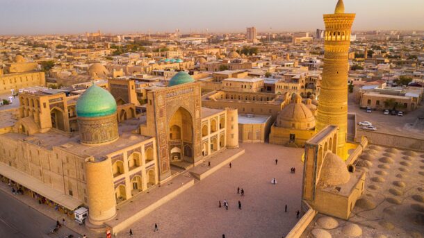
Aerial view of Bukhara
You will need to travel around 450 km (280 mi) from Khiva to reach Bukhara. The city’s history spans over two millennia, making it one of the oldest cities in the world. It’s filled with fairly impressive structures, such as the Po-i-Kalan Complex, Lyabi-Hauz, and the Ark of Bukhara.
At about 270 km (167 mi) from Bukhara lies Samarkand, a city that was the heart of the Timurid Empire. Samarkand is home to the Registan Square, an awe-inspiring public square surrounded by monumental madrasahs. Other must-visit sites include the Gur-e-Amir Mausoleum and Shah-i-Zinda. The city is a melting pot of cultures, heavily influenced by Timur’s (Tamerlane) conquests, and showcases a blend of Iranian, Indian, Mongolian, and Western Asian influences.
Samarkand to Shahrisabz and Tajikistan
To travel from Samarkand to Shahrisabz, you can choose between a train, a taxi, or self-driving. The journey by train takes around 2 hours and 16 minutes, while by taxi, it’s approximately 1 hour and 40 minutes. Shahrisabz is the birthplace of Amir Timur. If you decide to take the train, note that the service only runs once per week, and the ticket costs between $7 and $11. You can book a ticket online or from the station.

Brick walls of an Oasis City, on the Silk Road
One popular location is the Ak Saray Palace Complex, a structure with a 38-meter-high entrance portal that showcases intricate craftsmanship. Another hotspot is the Dorut Tilovat Complex & Kok Gumbez Mosque, which feature a mosque and a madrasa with significant historical importance. You may also want to visit the Dorus Siyadat Complex, which is home to the tombs of Timur’s sons. Finally, you can explore Chubin Madrasa (Amir Timur Museum), which houses artifacts and history related to Timur and the Koba Caravanserai, and ancient caravanserai which highlights the region’s historical trade importance.
Assuming you strictly adhere to this itinerary, Shahrisabz is your last stop in Uzbekistan. Generally, the most popular crossing is the Denau border, open 24/7 and accessible by public transportation. Other border crossings have limited hours and are not recommended for tourists.
The region around Dushanbe was inhabited by various empires and cultures, including Mousterian tool users, Neolithic cultures, the Achaemenid Empire, Greco-Bactria, the Kushan Empire, and the Hephthalites. Once in Dushanbe, you can visit the Hissor Fortress, which is a historical site dating back several centuries. Another popular location is the National Museum of Tajikistan and the Rudaki Park.
From Tajikistan to Kyrgyzstan: Dushanbe – the Fann Mountains – Khujand -Fergana Valley and Osh
The journey from Dushanbe to the Fann Mountains is an expedition into the heart of Tajikistan’s natural landscape. Reaching the Fann Mountains typically starts with a shared taxi ride to Penjakent, which serves as the gateway to these mountains. This trip covers approximately 230 km (143 mi) and costs around 70 TJS ($8) per person. From Penjakent, depending on your trekking plans, you can head to various points like Mogiyon for the Haft Kul or Artuch, the nearest village to the base camp for the Kulikalon lakes.
The Fann Mountains are a trekker’s hotspot, offering a landscape of semi-arid mountains, juniper forests, and pretty Carib-blue lakes like Alovaddin and Kulikalon. These areas are accessible only on foot is best to visit them between mid-June and mid-September.
Next, you will go to Iskanderkul Lake, which is nestled in the Tajik mountains. While direct public transport from the Fann Mountains to Iskanderkul is limited, you can take a private taxi from nearby Sarvoda.
The final leg of your Tajik journey leads to Khujand, one of the oldest cities in Central Asia. From Iskanderkul, you’ll find shared taxis to Khujand and the journey costs about 100 TJS ($11) per person.
Khujand, cradled on the left bank of the Syr Darya River and surrounded by orchard-draped mountains, dates from 2,500 years and was part of the Persian Empire. Known as a significant city along the ancient Silk Road, Khujand has witnessed the rise and fall of many empires, from Alexander the Great’s conquest in 329 BC, to the Umayyad and Abbasid Caliphates, and the Mongol Empire.
While in Khujand, you can visit the Sheikh Muslihiddin Mausoleum, Kamoli Khujandi Mausoleum, the Jami Mosque, the Historical Museum of Sughd, the Kamoli Khujand House Museum, and the Archaeological Museum, among others.
Starting from Khujand, you typically take a shared taxi to the city of Batken in Kyrgyzstan. From there, you can hire a taxi or take a shared car to the Kyrgyz customs post. After exiting Kyrgyzstan, a short walk through no man’s land brings you to the Tajik customs. Upon entry, shared cars or marshrutkas are available to take you from the border to Isfara in Tajikistan. The entire journey from Khujand to the border takes about 1.5 to 2 hours. In Isfara, you can find transportation to various destinations within Tajikistan, including back to Khujand.
The Fergana Valley, straddling Uzbekistan, Tajikistan, and Kyrgyzstan, is a region that includes destinations such as Margilon, Rishton, Kokand, Namangan, and Andijan. Margilon is famous for its vibrant Kumtepa bazaar and Yodgorlik Silk Factory, while Rishton is renowned for its centuries-old pottery-making tradition. Kokand, once the capital of the Kokand Khanate, includes architectural structures such as the Kudayar Khan Palace and the Jami Mosque.
Namangan was once a focal point for the Wahabi Islamic Movement of Uzbekistan, a radical Islamic sect. Today, however, this place has moved on from this turbulent period. Andijan, sometimes spelled Andijon is one of the oldest cities in the region and the birthplace of Babur, a historical figure who founded the Mughal dynasty of northern India.
Osh’s history starts back some 3,000 years. Located in the Fergana Valley, at the foot of the Pamir Mountains, Osh’s strategic position has made it a melting pot of various cultures and traditions. The city’s history is marked by its role as a major trading center on the ancient Silk Road, connecting China with the Mediterranean.
Dominating the skyline of Osh is the Sulaiman-Too Sacred Mountain, a UNESCO World Heritage Site. The Sulaiman-Too Mountain is regarded as one of Kyrgyzstan’s most important cultural and historical sites.
Security Warning: While the Fergana Valley is generally safe for tourists, it’s important to stay informed about the current situation, especially near border areas. Recent history has seen tensions and conflicts in the region, so staying updated with news before traveling in the area.
Fergana Valley – Bishkek – Lake Issyk-Kul, Jeti-Oguz, and Semenovskre Gorge
Traveling from the Fergana Valley to Bishkek can be an interesting journey, with several options available depending on your preferences for speed, cost, and scenic value. One of the most affordable and scenic ways to travel is by train, although it’s a longer journey. Initially, you would take a train from Margilon to Tashkent South, which takes about 5 hours and 23 minutes and costs between $7 and $10. The next leg is from Tashkent North to Turksib (Kazakhstan), a longer stretch of approximately 15 hours and 2 minutes, costing between $9 and $13. Finally, you would board a train from Turksib to Bishkek 2, which takes around 5 hours and 32 minutes and costs between $5 and $9. For train ticket information and purchases, check out Uzbekistan Railways and Kazakhstan Train Tickets.
For those preferring a faster route, flying is an option, albeit more expensive. Flights from Manas to Osh take about 40 minutes and cost between $27 and $400. There are also flights from Manas to Namangan, with varying durations and costs depending on the route and airline. These flights can take anywhere from 13 hours and 15 minutes to 22 hours and 50 minutes, with prices ranging from $170 to $800.
Alternatively, there’s the option of traveling by bus, which strikes a balance between cost and time. The bus journey from Tashkent bus station to Bishkek Zapadnyi Avtovokzal takes around 12 hours and 40 minutes and costs about $21. This route is a good middle ground for those who want a quicker journey than the train but at a lower cost than flying
Bishkek is the capital of Kyrgyzstan. In the Middle Ages, a settlement known as Dshul existed on the site of today’s city, which was eventually destroyed by the Mongols under Genghis Khan in the 13th century. For a long time after, the region was primarily inhabited by nomads. The modern city of Bishkek evolved from a caravan station on the Silk Road called Pishpek. In 1825, the Khan of Kokand fortified this station, but it was soon conquered by Russian Tsarist troops in 1862.
Key attractions in Bishkek include the Ala-Too Square, which is dominated by the grand statue of Manas. The State History Museum, which contains exhibits from antiquity to the 20th century, the Erkindik Park, the Panfilov Park, and the Russian Banya a Soviet-era bathhouse are presumed to have positive health benefits.
Lake Issyk-Kul is approximately 205.7 km (about 128 mi) from Bishkek, and there are several ways to reach this scenic destination. One option is to use one of the hourly buses from Bishkek Zapadnyi Avtovokzal to Cholpon-Ata near Lake Issyk-Kul. The journey takes around 4 hours and costs approximately 336 KGS ($4). Shuttles like Bex offer services from Bishkek to Lake Issyk-Kul, taking about 3 hours and 37 minutes. The estimated price for this service is around 3,780 KGS ($45). Hiring a taxi for the same route can take around 3 hours and 37 minutes, with an estimated cost of 4,200 – 5,460 KGS ($50 – $65).
The lake and its surrounding areas, including Rukh Ordo and Barskoon, offer a variety of outdoor activities. For example, you can enjoy swimming, boating, hiking, and horseback riding.
Jeti-Oguz, known for its pretty red sandstone formations, and Semenovskre Gorge, appreciated for its alpine scenery, are accessible from the Lake Issyk-Kul area and offer opportunities for trekking and enjoying the natural landscape. If you want to move directly from one location to another, it’s best to rent a car.
Karakol, located near the eastern tip of Lake Issyk-Kul, is reachable via bus from Bishkek, with the journey taking about 6 hours and tickets priced at around 420 KGS ($5). A shuttle from Bishkek to Karakol has an average duration of 5 hours and 34 minutes and costs around 5,712 KGS ($68). You can also take a taxi ride, which takes roughly 5 hours and 34 minutes and can cost between 6,720-8,400 KGS ($80 -$100).
Lake Issyk-Kul to Lake Song Kol
Traveling from Lake Issyk-Kul to Lake Song Kol involves a journey not the heart of Kyrgyzstan’s nomadic culture. Lake Song Kol is located at 3,016 m (9,900 ft) and is encircled by snow-capped mountains. To reach this beautiful destination, you’ll need a sturdy 4WD vehicle. The gateway town to Lake Song Kol is Kochkor, reachable approximately four hours from Bishkek or Karakol. From Kochkor, it’s a further two-hour drive to the lake’s banks. If you’re feeling adventurous, you could also opt for a horseback ride or hike to the lake, embracing the nomadic spirit of Kyrgyzstan. Once at Lake Song Kol, you can stay in a yurt, do day hikes, and try some horseback riding.
For a comprehensive tour covering both Issyk-Kul and Song-Kul lakes, prices vary depending on the group size. For instance, a tour for two people costs around $1050 per person, while the cost decreases with more participants, dropping to about $950 per person for groups of 6-10. These prices typically include transportation, meals, accommodations, and guided tours.
From Kyrgyzstan to China: The Torugart Pass
The Torugart Pass, part of the classic Silk Road route, is situated high in the Tian Shan mountains at an elevation of 3,752 m (about 12,310 ft). This makes the pass not only a spectacular scenic route but also a challenging one, often closed due to snow. The border is heavily controlled, requiring a special permit, guide, and pre-arranged transport on both sides.
The border crossing process involves multiple checkpoints and customs formalities. On the Chinese side alone, you may encounter up to three checkpoints. It’s important to note that the border is closed on weekends, Chinese holidays, and Kyrgyzstan holidays. The journey from the border to Kashgar spans about 180 km (111 mi) and takes approximately 4 hours.
Once in China, Kashgar, a famous city on the western edge, awaits. The city has been a melting pot of cultures and empires throughout its history. Located at the convergence of the Tien Shan and the Kunlun Mountains, it commanded significant caravan routes, including the famed Silk Road. The region has seen the rule of Chinese, Turkic, Mongol, and Tibetan empires and has been a site for numerous historical battles.
The city’s main attractions include the Old Town District, where you’ll find traditional workshops making pottery, colorful caps, and other folk handicrafts. Just a short bus ride away, you will find the Abakh Khoja Tomb, an Islamic mausoleum also known as the Fragrant Lady’s Tomb.
Other well-known landmarks include the Id Kah Mosque, one of the largest in China, and the Kashgar Bazaar, a market with over 5,000 stalls. If natural hotspots are your thing, you will likely enjoy Mt. Muztagh Ata, known as the ‘father of icebergs’, and Karakul Lake, a moraine lake. The Khunjerab Pass, close to the Pamirs and the Karakoram Range, is another significant site with historical importance.
Yet another interesting location is that of the Three Immortals Buddhist Caves. Dating back to the Eastern Han Dynasty (25-220 AD), these caves are among the earliest examples of Buddhist cave art in western China, possibly predating the famous Mogao Caves by 300 to 400 years. They were carved into a cliff beside the Qiakemake River, about 18 km (11 mi) from Kashgar City.
Finally, while in the area, you can also visit Stone City, a renowned historical site on the ancient Silk Road. More specifically, the Stone City is a ruined city that was famous for its location at the junction of the middle route and southern route of the ancient Silk Road.
Kashgar to Lhasa via Train
Traveling from Kashgar to Lhasa via train is a pretty long journey. There isn’t a direct train from Kashgar to Jiayuguan. For this reason, you will have to travel from Kashgar to Urumqi by train and then catch another train to Jiayuguan. Trains from Kashgar to Urumqi run multiple times a day, with travel times ranging from approximately 15 to 24 hours. Ticket prices vary based on the class, with hard sleepers costing around $47-48 and soft sleepers around $71-73.

Dunhuang – the eastern extreme of the Silk Road
Once in Jiayuguan, you can visit the western end of the Great Wall before continuing to Dunhuang. The distance between Jiayuguan and Dunhuang is not very long, and you can travel either by train or bus. Jiayuguan Pass, often hailed as the “First and Greatest Pass under Heaven,” is a critical part of the Great Wall and a symbol of China’s ancient military architecture. Constructed in the Ming Dynasty (1368–1644), it took 168 years to complete. The pass consists of an inner city, a central area with numerous buildings, an outer city, and a moat, covering a total area of 33,529 square m (40,100 square yards). Its architecture reflects a complex and integrated defensive system, with facilities like arrow towers, turrets, and cannons. The pass’s significance extends beyond its military role; it was a vital traffic fort along the Silk Road, linking China with Central Asia and Europe.
Dunhuang is famous for the Mogao Grottoes, a complex of Buddhist cave temples, and a UNESCO World Heritage site. The Mogao Caves were first constructed in 366 AD by a Buddhist monk named Le Zun, who had a vision of a thousand Buddhas bathed in golden light. This site served as a major hub on the Silk Road, facilitating not just trade but also the exchange of religious and cultural ideas. The caves were continuously expanded and adorned over a thousand years, through various dynasties, with the last construction completed during the Yuan Dynasty (1279-1368 AD).

Xinjiang Subashi Pass. At more than 4000 m above the sea level, the pass might have been part of the Silk Road
From Dunhuang, take a train to Lanzhou, the capital of Gansu Province. The final leg of the journey from Lanzhou to Lhasa can be completed by train. This route is part of the Qinghai-Tibet Railway, the world’s highest railway. The train journey from Lanzhou to Lhasa takes about a day and offers beautiful views of the Tibetan Plateau. You can find train schedules and book tickets online through various travel websites like China Highlights.
Exploring Tibet
The journey from Lhasa to Yamdrok Tso Lake is, to many, a breathtaking experience, traversing the Gampala Pass. This pass, at an elevation of 4,790 m (15,715 ft), offers good views of the Himalayan range. The trip covers approximately 110 km (68 mi) and typically takes about 2 hours by car.
Yamdrok Tso Lake, one of Tibet’s three holy lakes, is famed for its turquoise waters and the picturesque landscape that surrounds it. The lake, at an altitude of 4,441 m (14,570 ft), is considered a spiritual site and is often visited for this reason.
From Yamdrok Tso, the journey continues to Shigatse, Tibet’s second-largest city, covering around 350 km (217 mi). This part of the journey takes approximately 5 to 6 hours by road. En route, you may want to visit the Tashilunpo Monastery, an important center of Tibetan Buddhism and the seat of the Panchen Lama. This monastery, founded in 1447, is renowned for its massive Thangka wall, which is displayed during various Tibetan festivals.
The road from Shigatse to the Everest Base Camp (EBC) is about 350 km (217 mi) and takes roughly 7 hours. The journey winds through some of the most stunning landscapes in Tibet, including the Rongbuk Monastery – the highest monastery in the world. Even better, the EBC offers views of Mount Everest, which you might know is the highest peak on Earth, standing at 8,848 m (29,029 ft). No need to say, the base camp is a really cool destination for trekkers and mountain enthusiasts.
Lhasa is the capital of Tibet. Originally known as “Womatang”, it was merely a grazing land administrated by a small Tibetan tribe before the 7th Century. The transformation of Lhasa into a significant urban center began with Songtsn Gampo, the king who unified the Tibetan plateau and founded the Tubo Kingdom.
One key attraction is the Jokhang Temple, a pilgrimage site dating back to the 7th century. Another important location is Barkhor Street, a market area where one can experience local Tibetan life and buy traditional crafts and souvenirs. You may also want to visit the Potala Palace, an iconic landmark of Tibet that served as the winter residence of the Dalai Lamas. The palace stands atop Marpo Ri Hill and offers panoramic views of the city.
The most common mode of transportation for these journeys is by road, usually in a 4WD or a tourist coach, due to the rugged terrain. The cost of transportation varies based on the type of vehicle and the group size. Typically, a guided tour for this circuit, which includes transportation, accommodation, and entrance fees, can range from $500 to $1,000 per person.
An important thing to keep in mind is that this region is probably at a higher altitude than any other where you have set foot, meaning it may take you some time to acclimatize. It may be a good idea to have a day or two in Lhasa for acclimatization before heading to higher altitudes. Symptoms of altitude sickness should be taken seriously, and medical advice should be sought if needed.
Return to Lhasa and Chengdu
After exploring Tibet, you should return to Lhasa and, then, head towards Chengdu. The most common and scenic mode of transportation is, once again, by train. The Chengdu-Lhasa railway connects these two cities, covering a distance of approximately 3,360 km (2,088 mi). This journey takes about 36 hours. The train route passes through various provinces and landscapes, including grasslands, mountains, lakes, and possibly glimpses of wildlife like Tibetan antelope, yak, and wild donkeys. The trip lasts for about 35.5 to 36.5 hours, depending on the specific train and conditions. Ticket prices vary depending on the class. A hard seat costs about 308 CNY ($48), a hard sleeper is around 693 CNY ($108), and a soft sleeper is approximately 1,097 CNY ($171).
In Chengdu, one of the major attractions is the Panda Sanctuary. Chengdu is renowned for its research and conservation efforts in protecting the Giant Panda. The sanctuary allows visitors to observe these adorable creatures in a habitat designed to mimic their natural environment.
Chengdu-Xi’an
From Chengdu, you will head towards Xi’an on a high-speed train. The high-speed train from Chengdu to Xi’an takes approximately 3 to 4 hours. Ticket prices can vary but generally range from $50 to $150, depending on the class and specific train service.
Known for its historical significance, Xi’an traces its origins back to the Stone Age, Xi’an was first established as a capital by the Western Zhou Dynasty around 3,000 years ago. This period marked the beginning of Xi’an’s significance in Chinese history, with the city later serving as the capital for several dynasties, including the Qin, Western Han, and Tang dynasties.
The city, known as Chang’an in ancient times, was a focal point of Chinese culture and politics. During the Qin Dynasty (221-207 BC), Xi’an became the capital of the first unified China under Emperor Qin Shi Huang. This era saw the construction of the Terra Cotta Army, Xi’an’s most famous landmark.
The Western Han Dynasty (206 BC – 220 AD) further elevated Xi’an’s status as a major political and cultural center. It was during this time that the Silk Road originated from Xi’an, linking China with Central Asia and European countries. The city continued to thrive in the Tang Dynasty (618–907), becoming one of the largest and most prosperous cities in the world, renowned for its grand, symmetrical layouts and advancements in various fields.
During the 20th century, the city was an entry point for communist ideology from the Soviet Union, and in 1936, the Xi’an Incident led to the formation of a united front between the Communists and Nationalists against Japanese invaders.
A UNESCO World Heritage site and one of the most significant archaeological discoveries of the 20th century, the Terracotta Army was constructed by the first Emperor of China, Qin Shi Huang. Discovered in 1974, this vast collection comprises thousands of life-size soldiers, horses, and chariots, arrayed in battle formation. Each figure is unique, with distinct facial features, expressions, and attire.
Another key landmark is the Ancient City Wall, which was built in the 14th century during the Ming Dynasty. The Ancient City Wall is one of China’s best-preserved fortifications. Stretching over 13.7 km (8.5 mi), this colossal structure includes four main gates and watchtowers, used for surveillance and defense. Visitors can walk, cycle, or even rent a bicycle to traverse its length.
Other important landmarks are the Giant Wild Goose Pagoda, which was built to house scriptures brought from India, and the Shaanxi History Museum, which is home to over 370,000 relics, this museum traces China’s history from the earliest times to the late Qing Dynasty. Finally, you may also want to visit the Bell Tower and Drum Tower, which are adjacent structures dating back to the 14th century. The Bell Tower was used for timekeeping and news dissemination, while the Drum Tower housed a huge drum beaten at sunset.
From Xi’an to Beijing and, then, wherever you want
Trains departing from Xi’an North Railway Station arrive at Beijing West Railway Station, covering a substantial part of China’s vast landscape. Your best option is taking a high-speed train, as about 20 high-speed trains are running daily between these cities, with departures from early morning to late evening. The duration of the trip is between 4 and 6 hours, depending on the train. The cost for a second-class seat is around $86, a first-class seat at about $134, and a business-class seat can cost up to $260. Overnight sleeper trains are available. These trains offer a range of sleeping accommodations including deluxe soft sleepers, soft sleepers, hard sleepers, and hard seats, with prices ranging from $22 for a hard seat up to $65 for a deluxe soft sleeper.
Beijing is your final destination from the proposed Silk Road itinerary. Was quite a long trip, wasn’t it?
Beijing’s history is quite ancient. Known as one of the four great ancient capitals of China, alongside Xi’an, Luoyang, and Nanjing, the city’s roots can be traced back over 3,000 years. The city was initially known as Jin City during the Western Zhou Dynasty (11th century BC – 771 BC). Its significance grew after Emperor Qin united China in 221 BC, playing a pivotal role in northern China. It served as the capital during the Liao (916-1125), Jin (1115-1234), Yuan (1271-1368), Ming (1368-1644), and Qing (1644-1911) dynasties. The Forbidden City, a world-renowned landmark, was constructed in this period. Beijing became the capital of the People’s Republic of China in 1949 and has since grown into a global metropolis.
One of the most famous landmarks in the city is the Forbidden City, which is a palace complex from the Ming Dynasty. The construction of the complex started in 1406, and it took 14 years to complete. The complex consists of 980 surviving buildings covering 180 acres. It exemplifies traditional Chinese palatial architecture and is regarded as a masterpiece in the development of ancient Chinese architecture.
The Forbidden City was the center of power for the Qing dynasty until the end of imperial rule in 1912. The last emperor, Puyi, continued to live in the Inner Court until he was expelled in 1924. The complex was transformed into the Palace Museum in 1925, housing extensive collections of artwork and artifacts built upon the imperial collections of the Ming and Qing dynasties.
Another nearby world-renewed landmark is the Great Wall of China. The Wall is a series of fortifications made of stone, brick, tamped earth, wood, and other materials, generally built along the northern borders of China to protect the Chinese states and empires against the raids and invasions of the various nomadic groups from the Eurasian Steppe.
Several walls were initially built as early as the 7th century BC, which were later joined together and made bigger and stronger, mainly during the Ming dynasty (1368–1644). The most well-known sections of the wall were built during this period. The Great Wall stretches from Dandong in the east to Lop Lake in the west, along an arc that roughly delineates the southern edge of Inner Mongolia. The total length of the Great Wall is over 21,000 km (13,000 mi).
The Great Wall served multiple purposes. Apart from being a formidable defensive structure, it also regulated trade along the Silk Road, controlled immigration and emigration, and helped in imposing duties on goods transported along the Silk Road. Its structure included watchtowers, troop barracks, garrison stations, signaling capabilities through smoke or fire, and served as a transportation corridor.
While in the city, you can also explore the Summer Palace, Beijing National Stadium, Lama Temple, Beijing Capital Museum & the National Centre for the Performing Arts, Beijing Ancient Observatory (one of the oldest observatories in the world, dating back to 1442), Fayuan Temple, Beijing Temple of Confucius and Beijing Zoo.
Once you leave Beijing, I’ll leave it up to you where to go next. Options to consider include going back home, going to another destination that was part of the Silk Road, or going to a nearby location you’ve wanted to see for a long time.
For less independence, take a Silk Road guided tour
If you would rather explore ancient trade routes with the help of an organized Silk Road tour, there are many options you can consider. These tours usually take you to some or all of the following countries: Kazakhstan, Kyrgyzstan, Uzbekistan, Tajikistan, and Turkmenistan. Some tours also include Turkey and China.
Bottom line: You can make your own silk road
Now that you have a comprehensive Silk Road itinerary at your disposal, you are ready for the next step, which is to comprehensively research each destination so that you can assess whether you want to do the full itinerary or part of it.
Regardless of how you choose to make your itinerary, don’t forget that there was never a single road on which silk and other goods and knowledge were traded. This means that you can traverse the different networks that were part of the Silk Road in whatever order you want while still being able to say that you have traveled on the Silk Road. Cool, right?
Sources
Andrea, A. J. (2014). The silk road in world history: a review essay. Asian Review of World Histories, 2(1), 105-127. Link.
Chin, T. (2013). The invention of the Silk Road, 1877. Critical Inquiry, 40(1), 194-219. Link.
Mertens, M. (2019). Did Richthofen Really Coin” the Silk Road”? The Silk Road, 17(1), 1-9. Link.
Millward, J. A. (2013). The Silk Road: A very short introduction. Oxford University Press. Link.
Voya, D. (n.d.). [Untitled document]. Unesco.org. Link.