If you are into mountaineering or suspect you might be, consider challenging yourself to climb a mountain from time to time. Fortunately for you, the unprofessional climber enthusiast, there are peaks on almost every continent that are accessible enough for most people despite elevating you several thousand feet above sea level. We’re talking about peaks that are less technically challenging, pose less risk of altitude sickness, have less extreme weather, or require less time to ascend.
Let’s review some of the arguably easiest mountains to climb from almost every continent so you don’t need to transform overnight into a rugged, ice-axe-wielding conqueror. For each peak, I’ll delve into its elevation and location, pinpoint the best hiking season for each, introduce you to the local flora and fauna, and do my best to paint a vivid picture of the trek, among other things.
Europe – A place where you’ll find the Alps, the Carpathians, and the Pyrenees, among others
Coma Pedrosa, Andora

| Elevation | 2,943 m/9.656 ft |
| Location | Andorra, Pyrenees |
| Best Hiking Season | End of May to the end of October |
| Flora and Fauna | Pine, birch, and fir trees, ibex, vultures, eagles, and marmots |
Hiking details
Starting from Arinsal, the trail is initially marked with yellow dots and red and white stripes of the GR-11. Uncharmingly, the trek begins on a dirt road, winding up through a lush forest of red pine and fir. This initial section is rather straightforward, guiding hikers with signposts towards “Refugi i Alt del Comapedrosa”.
As the ascent continues, the path crosses small wooden bridges and enters a denser black pine forest. This segment offers an arguably serene backdrop, where you will be accompanied by the sound of nearby rivers, and during certain seasons, notice wild raspberries and blueberries.
At the Comapedrosa mountain pass, the landscape opens up to show the Pleta del Comapedrosa, a large plain that once served as grazing land for livestock. Once you have crossed this section, you’ll notice the terrain becoming rockier and the ascent more demanding.
The path to the summit intensifies as it climbs higher, eventually leading to the Estany del Comapedrosa, a small glacial lake near the peak. The trail splits here, offering two routes to the summit: a ridge path for those comfortable with heights and an alternative path that is less exposed. Both routes converge at the summit, where climbers typically enjoy the views of Andorra, Catalonia, and France.
An arguably interesting fact
Coma Pedrosa emerged as a recreational destination in the late 19th century, becoming one of Andorra’s first areas popular for skiing and hill walking.
Guided tours
Assuming you can wake up early in the morning, consider a Coma Pedrosa guided trekking tour so you won’t have to concern yourself about getting lost in one of Europe’s smallest countries.
Mount Olympus, Greece

| Elevation | 2,917 m/9570 ft |
| Location | Greece, Olympus Range |
| Best Hiking Season | June to September |
| Flora and Fauna | Pine, fir, birch forests, ibex, marmot |
Hiking details
The hike traditionally begins at the Prionia parking area, accessible by car or taxi from Litochoro. From Prionia, the path leads to the Spilios Agapitos Refuge, a popular rest stop for hikers aiming for the summit. This segment of the hike will take you through dense forests of pine, fir, and birch, with the flora transitioning as altitude increases.
The ascent from the refuge to Mytikas, the highest peak, involves a challenging scramble classified under the Yosemite Decimal System as Class III. This part of the hike is not just physically demanding but also requires a somewhat steady nerve and careful footing, especially on the loose gravel and rock faces encountered as one approaches the summit.
If you prefer a less technical challenge, alternative summits like Skala and Skolio offer pretty views as well, without the final scramble to Mytikas. Regardless of the chosen path, the hike will give you panoramic views that extend across the Greek landscape and, on clear days, as far as Albania and Bulgaria.
An arguably interesting fact
The mountain’s mythological significance as the dwelling of the Olympian gods adds a layer of mystique to the hike, meaning you will walk the paths where ancients believed the gods themselves trod.
Guided tours
If you are concerned about encountering an angry god while trekking the area, consider taking one of the several guided tours to Mount Olympus. If you want to start the trip from Athens or Thessaloniki, you will be glad to know that some of these tours start from these cities.
Tryfan, Wales

| Elevation | 917.5 m/ 3,010 ft |
| Location | Snowdonia National Park, Wales |
| Best Hiking Season | May to October |
| Flora and Fauna | Heather, bilberry, feral goats |
Hiking details
Tryfan is quite famous for its scrambling routes. The North Ridge is particularly popular, providing a direct and arguably exhilarating route to the summit. This scramble requires a good head for heights and perhaps some experience due to its exposure and the need for handholds.
Besides scrambling, Tryfan has several other climbing routes across its faces. The East Face, for instance, includes the South Buttress Grade 3 route and the North Buttress Grade 2 route, among others. These routes vary in difficulty and involve navigating a mix of slabs, cracks, and chimneys.
The summit of Tryfan is marked by the famous Adam and Eve rocks, two monoliths challenging climbers to leap across them to gain “the freedom of Tryfan” – a feat not without its risks due to the sheer drop on either side.
An arguably interesting fact
Tryfan is one of the most recognizable and beloved peaks in Britain, partly due to its unique shape and the adventurous scrambles it offers.
Guided tours
Tryfan is located in the region and national park known as Snowdonia or Eryri. Several guided tours in Snowdonia are available, including ones that take you to the summit.
Aiguille du Tour, France & Switzerland

| Elevation | 3,540 m/11,614 ft |
| Location | Mont Blanc Massif, France/Switzerland |
| Best Hiking Season | Summer for climbing; also accessible in winter on skis |
| Flora and Fauna | Edelweiss, alpine ibex, chamois, marmots |
Climbing details
The ascent to Aiguille du Tour involves a combination of glacier travel and rock scrambling. Starting from either Refuge Albert Premier or Cabane du Trient, you will first traverse the glacier, moving towards the Col du Tour. The climb from the col involves a scramble to the gap between the north and south summits, with the north summit being slightly higher. The final approach to both summits entails easy scrambling, suitable for those of you who can confidently claim they have basic mountaineering skills at best.
An arguably interesting fact
Aiguille du Tour was first climbed in 1926, and its relatively straightforward routes have made it a popular choice for novice mountaineers seeking alpine experience.
Guided tours
Unless you have experience with alpine climbing, it’s probably best to take an Aiguille du Tour guided tour. The available options include tours of varied difficulty levels, so you can choose the option most appropriate for your skill level and desired challenge level.
Monte Rosa, Switzerland & Italy

| Elevation | 4,634 m/15,203 ft |
| Location | Border between Switzerland and Italy |
| Best Hiking Season | Mid-July to Mid-September |
| Flora and Fauna | Edelweiss, ibex, chamois, marmots |
Climbing details
The approach typically starts at the Monte Rosa Hut, requiring a traverse of the glacier and a long ascent that can take 10-12 hours round trip. The route involves glacier travel, steep snow slopes, and at times, rock scrambling. The massif is known for its expansive glaciers and steep faces, particularly the east wall above Macugnaga, the highest mountain wall in the Alps.
An arguably interesting fact
The mountain’s name, “Monte Rosa,” does not derive from the color rose, but rather from the Arpitan word “rouése,” meaning “glacier.” This etymology reflects the mountain’s dominant feature, its extensive ice fields.
Guided tours
Besides the main summit routes, Monte Rosa offers the “Spaghetti Tour,” an opportunity to summit multiple peaks over several days. This trip begins in Cervinia and ends in Gressoney, traversing the high-altitude plateau of Monte Rosa and including peaks like Breithorn, Pollux, and Castor.
Africa – The place where you’ll find peaks such as Toubkal and Kilimanjaro
Mount Kenya, Kenya

| Elevation | 5,199 m/17,057 ft |
| Location | Central Kenya |
| Best Hiking Season | January to February, July to October |
| Flora and Fauna | Erica arborea, African sage Artemisia afra, elephants, buffalo, leopards |
Hiking details
Mount Kenya is a UNESCO World Heritage Site and Africa’s second-highest peak. The mountain’s landscape is marked by forests at lower altitudes, transitioning into alpine meadows and finally into a barren lunar landscape at the highest elevations.
The most popular route to the summit is known as the Sirimon route. Its popularity is due to its more gradual ascent, making it ideal for acclimatization. It passes through forests rich in wildlife, and alpine meadows, and leads to Point Lenana, the third-highest peak, offering stunning views of the Great Rift Valley and the summit glaciers.
The Chogoria route, on the other hand, is often recommended for the descent. It will give you a view of sheer cliffs, the Gorges Valley, and Lake Michaelson. The route’s lush landscapes are contrasted by the rugged terrain near the summit.
Finally, the quickest route to Point Lenana but also the steepest, making it a challenging ascent. It features the notorious vertical bog and leads through the Teleki Valley with its distinctive vegetation.
For those seeking more than hiking, Mount Kenya provides technical climbing opportunities, with Batian and Nelion peaks requiring experience in rock climbing.
An arguably interesting fact
The Kikuyu people face their homes towards the peak, believing it to be the dwelling place of Ngai, their God.
Guided tours
There are several tours to Mount Kenya, with duration ranging from one to several days. As you might suspect, the longer the duration, the more of the area you will typically see.
Find out more
To learn more about this mountain, feel free to check out an arguably fun guide to trekking Mount Kenya.
Mount Elgon, Kenya & Uganda

| Elevation | 4,321 m/14,177 ft |
| Location | Border of Kenya and Uganda |
| Best Hiking Season | Dry seasons: mid-December to March, June to July |
| Flora and Fauna | Over 400 plant species, elephants, buffaloes, antelopes, monkeys, 144 bird species including the endangered lammergeier |
Hiking details
Mount Elgon harbors several peaks aside from Wagagai, including Sudek and Koitobos, each offering its own unique vistas and challenges. You can approach the mountain from both the Uganda and Kenya sides, with various routes available. The Uganda side comes with routes like the Sasa River Route and the Sipi Route, which includes attractions such as waterfalls and hot springs. The Kenya side provides different approaches, with the possibility of exploring the Elgon caldera. The trek can span from three to more days, allowing for exploration of hot springs, the crater, and the summit.
An arguably interesting fact
The caves on Mount Elgon, such as Kitum Cave, are frequented by elephants and other wildlife seeking salt licks, adding to the mountain’s allure as a destination for wildlife enthusiasts.
Guided tours
While there are limited options available, tours to Mount Elgon do exist. When choosing a tour that is not very popular with tourists, it’s recommended that you do your best to find one that has at least some reviews.
Thabana Ntlenyana, Lesotho

| Elevation | 3,482 m/11,424 ft |
| Location | Lesotho, Maloti Mountains |
| Best Hiking Season | Varies, typically dry seasons |
| Flora and Fauna | Tussock grass, shrubs, Bush blackcap, Rudd’s lark |
Hiking details
Thabana Ntlenyana, translating to “beautiful little mountain” in Sesotho, stands as the apex of southern Africa within the Maloti Mountain range. This peak offers a two-day hike from Sani Pass. The ascent begins with a 4×4 journey up Sani Pass, where the landscape transforms dramatically as the altitude increases.
The path to Thabana Ntlenyana is less trodden and involves going through steep inclines, rocky outcrops, and sometimes crossing streams, depending on the season. The trek will give you views of the Drakensberg and Lesotho.
An arguably interesting fact
This peak is part of the “Grand Traverse” of the Maluti Mountains, a journey that encompasses the vast of this significant mountain range.
Guided tours
Tours in Lesotho will typically take you to multiple locations, with some including several days of trekking. You will notice that many tours available will take you to the Sanni Pass, which traverses the Drakensberg Mountains. If you want to reach the summit, make sure the tour explicitly says they will take you to Thabana Ntlenyana, as most do not take you beyond the Sanni Pass. If you start ascending to the summit from the Sanni Pass, note you will need to allocate about 2 days for it.
Mount Mulanje, Malawi

| Elevation | 3,002 m/9849 ft |
| Location | Southern Malawi, near Blantyre |
| Best Hiking Season | Dry season, from May to August |
| Flora and Fauna | Mulanje cedar, Mlanje Mountain chameleon, klipspringer |
Hiking details
Mount Mulanje has an extensive system of trails and huts, making it accessible for multi-day treks across its diverse landscape. The massif’s plateau, with elevations ranging from 1,800 m (5, 905 ft) to 2,200 m (7,217 ft), is dotted with rolling grasslands and intersected by deep, forested ravines. It features several peaks over 2,500 m (8,202 ft), including Chambe Peak, known for having the longest rock climb in Africa.
The massif’s unique position causes it to act as a rain barrier, with the plateau receiving over 2,500 mm (100 in) of rain annually, in contrast to the surrounding lowlands. This results in quite a rich biodiversity, supporting unique flora and fauna. The area is popular for both hiking and climbing, with numerous mountain huts scattered across the area, maintained by the Malawi Mountain Club (MMC) and the Forestry Department. These huts provide essential accommodation for adventurers exploring the massif.
An arguably interesting fact
Mount Mulanje is not just a hiker’s paradise but also an important ecological area and home to the Mulanje cedar, Malawi’s national tree. This species, unique to the massif, faces threats from illegal logging, highlighting the critical conservation efforts needed to protect this and other native flora.
Guided tours
Tours to Mount Moulanje can last for several days and many operators will allow you to customize your itinerary, choosing from several routes and peaks.
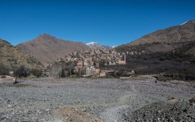
Jbel Toubkal

| Elevation | 4,167 m/13,671ft |
| Location | High Atlas Mountains, Morocco |
| Best Hiking Season | June to September |
| Flora and Fauna | Thuriferous Juniper, oak forest, Bearded Vulture, the Barbary sheep, the Magot Monkey |
Hiking details
The hike to Mount Toubkal, also known as Jbel Toubkal, typically starts from Imlil. The ascent involves an overnight stay at the Toubkal Refuge, with the final push to the summit early on the second day.
Begin in Imlil, you will ascend towards the refuge through scenic trails, covering approximately 10 km (6.2 miles) with significant elevation gain. Summit push pre-dawn, navigating steeper paths and rocky terrain to reach the peak at 4,167 m (13,671 ft), then return to the refuge or Imlil.
An arguably interesting fact
Jbel Toubkal is a cultural hub for Berber communities whose traditions and ways of life have been preserved through the centuries.
Guided tours
With Morocco being one of the most popular travel destinations in Africa, there are plenty of Atlas Mountains tours from which you can choose, with some of them taking you to Mount Toubkal. These tours will often start from Marrakech, which is a city that you may want to explore either before or after trekking the Atlas.
Find out more
If you feel ready to learn more about this place, check out our full Mount Toubkal trekking guide.
Ras Dashen

| Elevation | 4,550 m/14,928 ft |
| Location | Simien Mountains National Park, Ethiopia |
| Best Hiking Season | October to March |
| Flora and Fauna | Afro-alpine vegetation, Gelada baboons, Ethiopian wolves |
Hiking details
A trip to Ras Dashen typically commences in Debark. From there, the trail meanders through deep valleys, across what some would call dramatic cliffs. You will follow ancient goat trails that meander across even terrains. The journey can extend for up to 12 hours, with seven hours dedicated to ascending and five to descending.
The return trip can be done on foot or with one of the minibuses and cars await just a short stroll from the peak, ready to take tired travelers to Dilibza on a high-altitude road.
An arguably interesting fact
Simien Mountains National Park, where Ras Dashen is located, has been designated a UNESCO World Heritage site.
Guided tours
Tours to the Simien Mountains vary significantly in length, with some lasting for as much as a week. If you plan to reach Ras Dashen, make sure to choose a tour that is clear about the peak being part of the itinerary.
Mount Stanley

| Elevation | 5,109 m/16,762 ft |
| Location | Rwenzori Mountains, Uganda/DRC border |
| Best Hiking Season | June to August, December to February |
| Flora and Fauna | Giant lobelias, heather trees, the Rwenzori turaco, forest elephants |
Hiking details
Mount Stanley, also known as Mount Ngaliema, is the highest peak of the Rwenzori Mountains and offers one of Africa’s most challenging trekking experiences. Trekkers typically start the trip from the town of Kasese and last for several days. Along the hike, you will experience a variety of ecosystems, including tropical rainforests, alpine meadows, and snow-capped peaks. The most famous route is the Central Circuit Trail, which offers nice views of the mountain’s twin summits, Margherita and Alexandra peaks.
An arguably interesting fact
Mount Stanley supports life forms found in very few places on Earth such as the giant groundsel.
Guided tours
If you would rather reach Mount Stanley with a guided tour, there are a few options for you to consider. When you cannot find customer reviews for a specific itinerary, it’s probably a good idea to at least check the reviews of the company offering the trekking experience.
Asia – Where you can trek the Urals, the Himalayas, and the Karakoram, among others
Mount Bazardüzü

| Elevation | 4,466 m/14,656 ft |
| Location | Greater Caucasus range, Azerbaijan/Russia border |
| Best Hiking Season | July, August, September |
| Flora and Fauna | Alpine and subalpine meadows, East Caucasian ibex, chamois |
Hiking details
Mount Bazardüzü is a rather isolated mountain, which makes it a distinctive summit in the Caucasus region, with the first ascent recorded in 1847. The common route from the Azerbaijan side starts from the south over gravel back up to the uppermost northeast ridge and through it to the summit. The climb involves navigating through scree, grassy areas, and finally, a snow field near the summit.
An arguably interesting fact
Bazardüzü marks the border between Europe and Asia. Its location just north of the Caucasus main ridge places the mountain entirely within Europe, according to certain geographical definitions.
Guided tours
If a private tour to Bazardüzü is your thing, then you have a 2-day organized hiking trip to consider. Some group tour options are also available, such as the one offered from time to time by Mountain Freaks.
Jhomolhari Trek, Bhutan

| Elevation (Highest Point) | 4,950 m/16,236 ft |
| Location | Jigme Dorji National Park, Bhutan |
| Best Hiking Season | March to June, October to November |
| Flora and Fauna | Rhododendron forests, Himalayan blue sheep (bharal) |
Hiking details
You will likely start the trek from Paro to Shana Zampa. As you progress, the trail takes you through Jigme Dorji National Park, where you’re surrounded by pine, ferns, oaks, and spruce. Highlights include the initial ascent from Shana Zampa to Soi Thangthangkha, where you’ll get your first view of Mt. Chomolhari if the weather allows it.
One of the most significant stops is at Jangothang, the base camp of Mt. Chomolhari, which offers pretty vistas and also serves as a key acclimatization point. Here, you can also take a look at Mt. Jichu Drake. The trek involves crossing high mountain passes such as Nyile La and Yele La. The trip will expose you to the traditional Bhutanese way of life in villages and herder camps along the route.
An arguably interesting fact
Mt. Jomolhari is regarded as a sacred mountain and climbing Jomolhari is prohibited.
Guided tours
A tour on the Jhomolhari Trek can last for as many as 14 days, so make sure to find an offer that takes you to the destination within a timeframe you find acceptable.
Mount Bromo, Indonesia

| Elevation | 2,329 m/7,641 ft |
| Location | Bromo Tengger Semeru National Park, East Java, Indonesia |
| Best Time to Visit | June to October, with the Kesada/Kesodo festival in August for the Tengger people |
| Flora and Fauna | Javanese edelweiss, Java’s savannah, sand sea, besra, green peafowl, leopard |
Hiking details
The trek to Mount Bromo should begin in the early hours if the goal is to catch the sunrise from the observation deck known as King King Kong Hill. This is a hike with several other vantage points giving views of the active crater and the Tengger Massif.
You will return across the Sea of Sand, the vast, desolate landscape that surrounds the volcano. This part of the trek is quite a contrast to the ascent, as you navigate through the sand’s soft, undulating patterns, often against a backdrop of swirling volcanic ash carried by the wind.
An arguably interesting fact
While trekking in the area, you might notice blue flames that appear around the crater, which are caused by the combustion of sulfuric gas.
Guided tours
If you want to see a cool sunrise with a guided Mount Bromo tour, you’re in luck, as there are quite a few available. Better yet, you also have camping options available that would allow you to take a look at the Milky Way before enjoying a popular sunrise experience.
Mount Fuji, Japan

| Elevation | 3,776 m/12,389 ft |
| Location | Shizuoka and Yamanashi Prefectures, Japan |
| Best Time to Visit | Early July to early September |
| Flora and Fauna | Japanese hemlock, the Fuji thistle, Asiatic black bears, Japanese serow |
Hiking details
Mount Fuji offers four main trails, each starting from a different 5th Station and varying in difficulty, length, and landscape. The Yoshida Trail is the most popular and accessible, with many huts along the route. It’s known for its sunrise views.
During the official climbing season, the mountain is bustling with hikers, and that can be either a good or a bad thing, depending on your preference. Off-season climbs are not for everyone due to harsh weather conditions and lack of facilities.
An arguably interesting fact
Mount Fuji has been a pilgrimage site for centuries.
Guided tours
If you’re in Tokyo, you’ll be glad to know there are plenty of tours that start in the city and take you to Mount Fuji.
Find out more
To learn more about this mountain, consider checking out a cool Mount Fuji trekking guide.
Mount Kinabalu, Malaysia

| Elevation | 4,095 m/13,435 ft |
| Location | Sabah, East Malaysia on the island of Borneo |
| Best Time to Visit | February, March, and April during the dry season. Avoid October to January due to monsoon season |
| Flora and Fauna | Orchids, ferns, pygmy squirrels, fruit bats, Orangutans, the Slow loris, Tarsier |
Hiking details
Mount Kinabalu offers two main summit trails: the Ranau Trail and the Kota Belud Trail, both starting from Timpohon Gate and converging at Sayat-Sayat Checkpoint before the final ascent to Low’s Peak
Accommodation options are available at Panalaban Basecamp for climbers to rest before their early morning summit attempt. Bookings for these accommodations need to be made well in advance due to high demand.
An arguably interesting fact
Kinabalu Park is a UNESCO World Heritage site, renowned for its tremendous biological and botanical diversity. For example, you might see unique vegetation, including the famed Rafflesia, the world’s largest flower.
Guided tours
There are quite a few tours around Kinabalu Park, including some that take you to Mount Kinabalu.
Mount Apo, the Philippines

| Elevation | 2,954 m/9,692 ft |
| Location | Davao City and Davao del Sur in the Davao Region, and Cotabato in Soccsksargen, Mindanao, Philippines |
| Best Time to Visit | March to May during the dry season |
| Flora and Fauna | Unique orchids and pitcher plants, the Philippine Eagle, gymnures, civet cats, deers |
Hiking details
Mount Apo comes with various trails you can try, with the Kidapawan-Magpet Trail being the most accessible. You will typically explore for 3-4 days and you’ll need to hire a guide and secure a permit.
An arguably interesting fact
The Lumad tribes consider Mount Apo as the dwelling of Apo Sandawa, a deity.
Guided tours
Since you cannot explore the mountain by yourself, you will have to use a guide. Some guided tours to Mount Apo can be booked online, including the 3-day tours to Mount Apo offered by Trail Adventurous.
Doi Inthanon, Thailand

| Elevation | 2,565 m/8,415 ft |
| Location | Chiang Mai Province, Northern Thailand |
| Best Time to Visit | November to February for the best views and cool weather. The park is cooler year-round compared to other regions in Thailand |
| Flora and Fauna | Loud forests, sphagnum bog, elongated tortoises, Asian black bears |
Hiking details
Doi Inthanon National Park comes with several trails suitable for different levels of hikers, with the Kew Mae Pan and Pha Dok Siew trails being more popular. The Kew Mae Pan trail is a well-maintained path and still mandatory to be accompanied by a local guide. The Pha Dok Siew trail offers a closer look at several waterfalls; it also requires a guide.
An arguably interesting fact
The park has several elephant sanctuaries, meaning you can interact with these animals in their natural habitat.
Guided tours
Considering that you will not be able to explore the mountain by yourself, you may well consider booking a tour to Doi Inthanon before leaving your home. Some tours will also take you to elephant sanctuaries, such as the Meaklang Elephant Sky Camp.
North and Central America – A place where you can climb the Rockies, the Appalachians, and the Sierra Madre, to name a few
Mount Chirripó, Costa Rica

| Elevation | 3,821 m/12,536 ft |
| Location | Chirripó National Park, Costa Rica |
| Best Time to Visit | The dry season from January to April, with February and March offering the best weather conditions |
| Flora and Fauna | Cañuela Batamba (Batamba fescue), mosses, ferns pider monkeys, Baird’s tapirs, peccaries, jaguars, pumas |
Hiking details
Mount Chirripó‘s trail starts in the village of San Gerardo de Rivas. Climbers must obtain a permit in advance, and reservations are needed for overnight stays at Crestones Base Camp or other refugios along the trail. Once at a certain altitude, you might be able to see both the Pacific Ocean and the Caribbean Sea, provided you’re in luck and there’s good weather.
An arguably interesting fact
In the language of the native Costa Ricans, Mount Chirripó means “Land of Eternal Waters”, a name that was probably given due to the many lakes and streams around the mountain.
Guided tours
Among the few tours available, you may want to consider the 4 days Chirripó guided ascent offered by a local IFMGA certified professional, as both the tour and the guide have gathered a few reviews that can inform your decision.
Pico Turquino, Cuba

| Elevation | 1,974 m/6,476 ft |
| Location | Sierra Maestra mountain range, Santiago de Cuba Province, Cuba |
| Best Time to Visit | Dry season from mid-October to April |
| Flora and Fauna | Tabebuia oligolephis, Magnolia cubensis, the bee hummingbird, Anetia cubana, conga hutia |
Hiking details
Two main routes lead to the summit: one starting from Alto del Naranjo in Granma Province, offering a historical route that includes Comandancia de la Plata, and the other from Las Cuevas on the southern coast, providing a shorter but steeper climb. The hike typically spans over two days, with most hikers reaching the summit on the first day and spending the night in Aguada de Joaquín.
An arguably interesting fact
The mountain houses La Comandancia de la Plata are Fidel Castro’s former rebel headquarters, meaning Pico Turquino is a cool destination for history nerds as well.
Guided tours
There are a few group and private tours to Pico Turquino from which to choose. In many cases, you will depart from Santiago de Cuba and spend around 2 days trekking the mountain.
Guadalupe Peak, Texas, USA

| Elevation | 2,667 m/ 8,751 ft |
| Location | Guadalupe Mountains National Park, Texas, USA |
| Best Time to Visit | The dry season, which runs from spring to fall, is ideal to avoid extreme heat and afternoon thunderstorms |
| Flora and Fauna | Desert shrubs, pinion pine, Elk, gray foxes, black bear |
Hiking details
The hike to Guadalupe Peak is a 13.5 km (8.4 mi) round trip with a 3,000 ft (914 m) elevation gain. It takes an average of 6 to 8 hours to complete. While on the trail, you’ll enjoy views of the Guadalupe Mountains National Park. The trail is marked by a series of switchbacks, especially steep during the first mile and a half. As you ascend, the vegetation changes from desert shrubs to a more forested environment. The final push to the summit presents the most exposed sections of the trail with narrow paths and steep drop-offs, demanding caution.
An arguably interesting fact
Guadalupe Peak has a stainless steel monument placed by American Airlines at its summit.
Guided tours
There aren’t that many organized trips available in the area. One option to consider is a tour to Guadalupe Peak that also takes you to the Carlsbad Caverns.
Cloud Peak, Wyoming, USA

| Elevation | 4,013 m/13,167 ft |
| Location | Bighorn National Forest, Wyoming, USA |
| Best Time to Visit | Snow melts out earlier in the Bighorn Mountains, making early summer to early fall ideal for hiking |
| Flora and Fauna | Spruce, fir, alpine grasses, sedges, moose, deer, bighorn sheep. |
Hiking details
The hike to Cloud Peak in the Cloud Peak Wilderness of the Bighorn Mountains covers a round-trip distance of 38.3 km (23.8 mi) with an elevation gain of approximately 1,565 m (5,135 ft). Most people complete this as a multi-day backpacking trip, utilizing campsites along the route such as Mistymoon Lake.
An Arguably interesting fact
The area is less traveled compared to other Wyoming ranges, meaning you can immerse yourself in a rather unspoiled wilderness.
Guided tours
There are few tours available and if you want professional company, you might end up with a custom Cloud Peak tour.
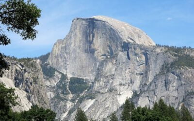
Half Dome, California, USA

| Elevation | 2,695 m/8,844 ft |
| Location | Yosemite National Park, California, USA |
| Best Time to Visit | The cables on Half Dome are up from the Friday before Memorial Day in May through the day after Columbus Day in October, which is the recommended season for attempting the hike |
| Flora and Fauna | Western white pine, giant sequoias, monkeyflower, California ground squirrel, mule deer, black bears, |
Hiking details
The Half Dome hike is a strenuous, 22 to 25 km (14-16 mi) round-trip journey that gains 1,463 m (4,800 ft) in elevation. You should be able to complete the trek in 10 to 12 hours. It begins from Yosemite Valley and includes the famous cable route for the final 121 m (400 ft) to the summit. Key challenges include navigating the subdome and the cable route, which can be particularly daunting due to its steepness and the smooth, worn granite surface.
An arguably interesting fact
Half Dome is called like this due to its peculiar shape, resembling a dome cut in half.
Guided tours
As some of you might suspect, there are many guided tours in Yosemite National Park and some of them will take you to spots from where you can see Half Dome. If you are looking for a guided tour to the summit, consider going with the high-rated YExplore Yosemite Adventures tour company. The Half Dome guided trip they offer includes preparation, trail knowledge, and coaching, including assistance on the cables.
Find out more
To learn more, consider checking out this guide on how to hike Half Dome and enjoy it.
Mount Olympus, Utah, USA

| Elevation | 2,751 m/9,026 ft |
| Location | Near Salt Lake City, Utah |
| Best Time to Visit | Spring, Summer, and fall |
| Flora and Fauna | Quaking aspen, Common Dandelion, Dyer’s Woad, bighorn sheep, mountain lions, red foxes |
Hiking details
The trail gains nearly 1,463 m (4,800 ft) in elevation over a distance of approximately 10.6 km (around 6.6 mi) round trip. The hike is divided into distinct sections, with a steep part known as “Blister Hill” occurring midway. The final 183 m (about 600 ft) consists of an easy scramble to the summit, which can be slick when wet.
An arguably interesting fact
Hiding near the base of Mount Olympus is Utah’s second deepest, and the United States’ 13th deepest cave, known as Neffs Cave.
Guided tours
Guided trips are not abundant but you can still find certified guides taking you to Mount Olympus if you wish to.
Camelback Peak, Arizona, USA

| Elevation | 824 m/2,704 ft |
| Location | Phoenix, Arizona, USA |
| Best Time to Visit | October to April to avoid the extreme heat of the Phoenix summer |
| Flora and Fauna | Saguaro, barrel, saguaro cactus, venomous rattlesnakes, cottontail rabbits, Harris antelope squirrels |
Hiking details
Camelback Mountain features two main trails to its summit: the Echo Canyon Trail and the Cholla Trail. Both trails are considered quite difficult, as they consist of exposed rock, strenuous climbs, and sections requiring hand-over-hand climbing. The Echo Canyon Trail is approximately 4 km (2.5 mi) round trip, featuring steep grades, railings for assistance on the toughest sections, and large boulders near the summit. The Cholla Trail is slightly longer and takes a more gradual ridge line up to the summit. The trail is well-marked and involves a rock scramble in the last 0.8 km (0.5 mi).
An arguably interesting fact
Camelback Mountain has a unique geological feature: its shape resembles a camel’s hump, giving it its name.
Guided tours
If you are looking for a guided tour to Camelback Mountain that has good reviews, you’re in luck, as there’s at least one that meets the criteria.
South America – The continent where you can trek the Andes, the Cordillera Blanca, or the Cordillera del Paine, among others
Chachani, Peru

| Elevation | 6,075 m/19,931 ft |
| Location | About 20 km (12 mi) north of Arequipa, Peru |
| Best Time to Visit | From the end of fall to early winter (May to July), due to nicer weather and more chance of climbing on snow |
| Flora and Fauna | Spiny succulents, turf grasses, Andean condor, woolly vicuñas, alpacas |
Hiking details
You should manage to climb Chachani in two days, starting from Arequipa. The ascent begins at a col with an altitude of 5,000 m (16,404 ft), reaching the base camp, Campo Inca, at 5,250 m (17,224 ft). The summit push starts early on the second day, with climbers reaching the top to witness the sunrise and panoramic views of neighboring peaks. The summit of Chachani is at 6,075 m (19,931 ft).
There are three main routes to the summit. The Azufrera Route is sometimes regarded as the traditional one. Easy by mountaineering standards but has had reports of dangerous conditions due to rockfalls. The Northern Scree Route is anothereasy route from the north, less exposed and with less altitude difference than the Azufrera route. Approaches from the south, longer with a greater altitude difference but accessible by public transport is the Cabrerías Route.
An arguably interesting fact
Chachani is often touted as the easiest 6000-meter mountain in the world. Whether this is really the case or not, we don’t know, as there’s a certain level of subjectivity involved. ????
Guided tours
You can climb the Chachani volcano with a guided tour that will be nice enough to pick you up from your hotel.
Ritacuba Blanco, Colombia

| Elevation | 5,330 m/17,749 ft |
| Location | National Park of El Cocuy and Guican, in the province of Boyacá, Colombia |
| Best Time to Visit | The best season for climbing is between December and February when the weather is more stable and conducive for climbing. |
| Flora and Fauna | Yellow-flowered Frailejón, tapirs, white-tailed deer, pumas, tufted Capuchin monkeys, spectacled bears |
Hiking details
The journey to Ritacuba Blanco begins from either the town of El Cocuy or Guicán. To reach the base camp of Ritacuba Blanco, travelers often take a truck from Guican early in the morning, which also collects milk from farms along the way.
There are two main routes for climbing Ritacuba Blanco. The Normal Route is a relatively easy walk on the glacier and is preferred by most climbers. The East Wall Route, on the other hand,is considered one of the most challenging routes in Colombia, and more suitable for those of you looking for technical rock climbing.
An arguably interesting fact
From Ritacuba Blanco you can see the rest of the park as well as Colombia’s eastern plains, called the Llanos Orientales.
Guided tours
For some reason, Ritacuba Blanco is not a place that attracts many trip organizers. One interesting option available is a 15-day guided tour to Ritacuba Blanco, a trip during which you will explore plenty of places, with Day 12 being the summit day.
Ojos del Salado, Chile

| Elevation | 6,891 m/22,608 ft |
| Location | On the border between Chile and Argentina in the Atacama Desert |
| Best Time to Visit | November to March, during the Southern Hemisphere’s summer. |
| Flora and Fauna | Lichens, mosses, ducks, flamingos, guanacos, vicuñas |
Hiking details
Climbing Ojos del Salado involves a combination of high-altitude trekking and somewhat technical mountaineering. There are routes starting from both the Chilean and Argentinian sides, with the Chilean route being the most commonly used for summit attempts. The climb typically requires acclimatization days at various camps along the route due to the extreme altitude.
An arguably interesting fact
Ojos del Salado is not only the highest volcano in the world but also holds the title for having the highest lake on Earth, located in one of its craters at an altitude of approximately 6,390 m (20,965 ft).
Guided tours
One of the more challenging peaks from this list, it seems like a good idea to reach Ojos del Salado with an organized tour. During the trek, you will most likely also explore the Atacama Desert.
Australia – That country where you’ll find Australian Capital Territory, New South Wales, and Northern Territory, among others.
Mount Kosciuszko, Australia
| Elevation | 2,228 m/7,310 ft |
| Location | Snowy Mountains, New South Wales |
| Best Hiking Season | December to March |
| Flora and Fauna | Alpine herbfields, snow gums, wombats, wallabies, and Australian ravens |
Hiking details
The most popular route to Mount Kosciuszko’s summit is via the Thredbo chairlift, which takes you to the starting point of a paved path that makes the ascent accessible to most people. This path, known as the Kosciuszko Walk, stretches approximately 13 km (8 mi) and traverse through striking alpine landscapes, characterized by vast herbfields and the twisted snow gums
An arguably interesting fact
There are several native Aboriginal names associated with Mount Townsend but there is some confusion as to the exact sounds. These are Jagungal, Jar-gan-gil, Tar-gan-gil, Tackingal; nevertheless, all of them mean Bogong Moth, which aestivate on the mountain.
Guided tours
There are only a few tours available. One guided tour of Mount Kosciuszko that I was able to find lasts for 4 days and has quite an interesting itinerary.
Antarctica – The place where you can find explore places such as the Transantarctic Mountains, Bunger Hills, and Tangra Mountains, among other Polar ranges
While hiking in Antarctica is a thing, there is no such thing as “easy mountains to climb”.
Bottom line: There’s a mountain peak for almost anyone
By now you know that not all mountain peaks require you to be an experienced climber that may well be capable of reaching Everest if they wanted to. Many famous and relatively famous peaks can be reached by almost anyone provided they know what they are into. In many cases, you won’t even need ice axes or Sherpas here; a granola bar and a bottle of water might just be enough. Almost enough. And if unsure you’re ready for it, check out how to get ready for trekking at high altitudes.
But with so many options available, how do you pick your first summit? Hard to give a universal answer; however, for most of you, it’s probably best to start with the place that it’s closer to you or that you really want to trek.
In other words, if you are located in North America, perhaps it’s best to start with a nearby peak, such as Half Dome. If you’re in Europe, then some summit in the Alps that is not Mount Blanc might be a good start. For Africans, Toubkal and Mount Kenya sound like good options. For South Americans, a good pick would be Chachani. For East Asians, it could be Mount Fuji; for Western ones, it could be somewhere in the Caucasus region. For Australians, Mount Kosciuszko is quite an interesting option. For Antarcticans, it’s whatever peak they think they can handle.
Last but not least, if you happen to find your first summit climb overly exhausting, don’t be quick to conclude mountaineering is not for you. It may just mean that peak wasn’t for you or you were not ready for the trip. The more you climb, the better you should get at it.