The Karakum Desert covers about 70% of Turkmenistan, spanning about 350,000 sq km (135,000 sq mi). One of the most iconic features of this desert is the Darvaza Gas Crater, also known as the “Door to Hell.” While camping near a crater that has been burning continuously for decades can be fun, Karakum is also a place where you might want to explore canyons and bronze age sites and visit semi-nomadic villages, among others. If you want to learn more, keep on reading, as I have a guide on how you could trek the Karakum Desert in 7 days.
Some Karakum Desert facts
Assuming you don’t want to explore the Karakum without knowing a few things about it, here is some intel. The desert stretches 800 km (500 mi) from west to east and 500 km (300 mi) from north to south. This vast area is bordered by the Caspian Sea to the west, the Amu Darya River to the northeast, and the Kopet Dag Mountains to the south. The landscape is quite diverse (by desert standards), as it has sand dunes, rocky plateaus, salt pans, and desert lakes.
The Karakum is divided into three regions: the elevated northern Trans-Unguz Karakum, the low-lying Central Karakum, and the southeastern Karakum, home to a series of salt marshes. The northern part of the desert is more arid and characterized by the dry bed of the ancient Uzboy River, while the southern region is watered by the Murghab and Tejen rivers, providing irrigation for oases such as Merv and Mary.
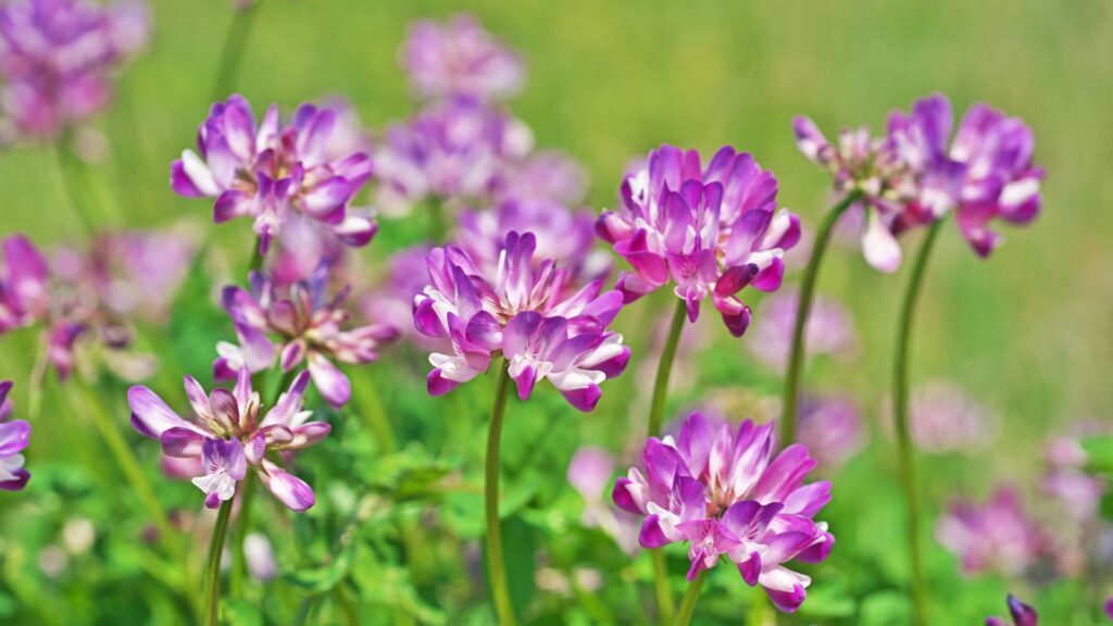
Common vegetation includes sandy sedge, sandy acacia, astragalus, and saxaul. During spring, the desert blooms with plants that cover the landscape before drying up by early May. Vegetation is sparse in the dune regions, which occupy about 5% of the desert.
Here are some Astragalus
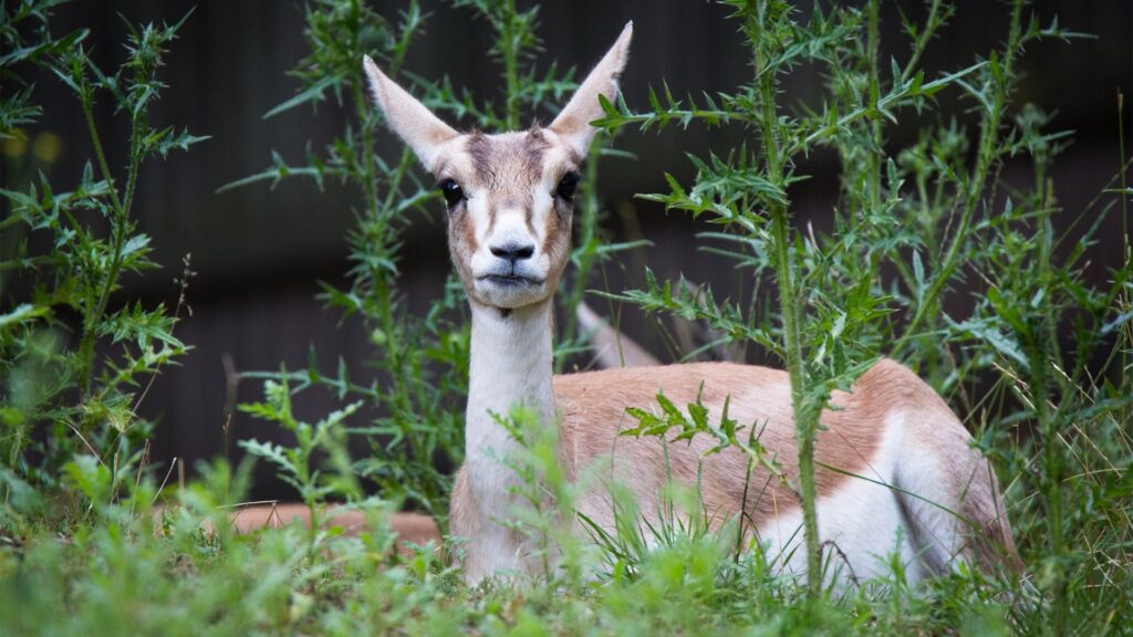
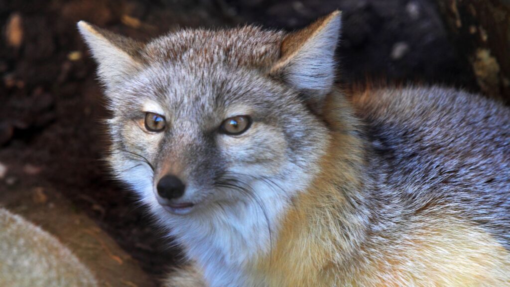
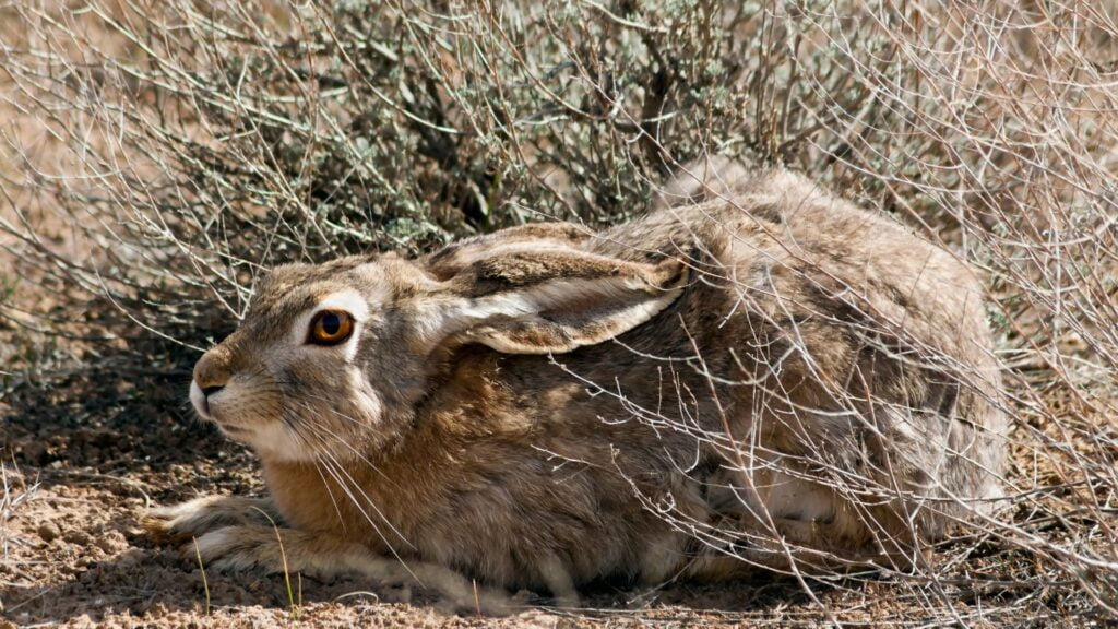
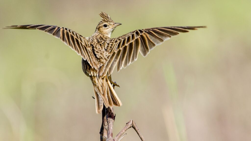
Insects and arthropods such as ants, termites, spiders, dung beetles, and dark beetles are fairly abundant. Reptiles are also common, with species like the Central Asian gray monitor lizard, various turtles, and several types of snakes and lizards making the desert their home. Bird species include desert sparrows and crested larks, while mammals like the tolai hare, goitered gazelle, camels, and corsac fox can also be found.
A serious-looking goitered gazelle
This is how a corsac fox looks like
And this is a tolai hare
Crested larks are like this
The Karakum Desert played a significant role in the history of the Silk Road. One of the key sections of the commercial network is the Zarafshan-Karakum Corridor, stretching 866 km (538 mi) through rugged mountains, fertile valleys, and the desolate Karakum Desert. This corridor linked various routes from all directions, serving as an artery for trade and cultural exchange between the 2nd century BCE and the 16th century CE, connecting major trading hubs like the oasis of Merv, a significant stopover that flourished due to its strategic location.
The Karakum Desert in 7 Days trekking itinerary
You can explore many of the Karakum’s most interesting locations in less than 7 days. If, however, you want to explore most of the desert’s interesting locations at a relaxing pace, 7 days is probably the minimum you need. Note that you cannot explore the desert and any parts of the country except the capital without the company of a local guide. Here are more details that might come in handy.
Day 1: Welcome to Ashgabat
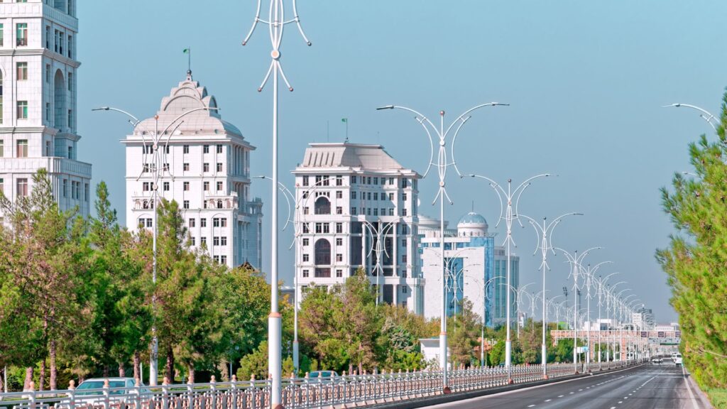
If you start your trip directly from Turkmenistan, there’s a good chance you will start it from Ashgabat – the capital of Turkmenistan. Known as the “City of White Marble,” it holds the Guinness World Record for the highest density of white marble-clad buildings. There are 543 new buildings clad with 4,513,584 sq m (48,583,619 sq ft) of white marble. The main avenue, Bitarap Türkmenistan Sayolu, is 12.6 km (7.83 miles) long and lined with 170 buildings clad with a total of 1,156,818 sq m (12,451,835 sq ft) of white marble.
Some of Ashgabat’s famous marble buildings
While in the city, you can see the Ashgabat National Museum of History, which houses over 500,000 exhibits, including paintings, drawings, sculptures, carpets, fabrics, household utensils, musical instruments, weapons, jewelry, historical documents, fossils, ivory horn-shaped vessels, Parthian goddess statuettes, and Buddhist vases. Another significant historical site is the Parthian Fortresses of Nisa, a UNESCO World Heritage Site that was once a major city in the Parthian Empire.
Some tourists also visit the Turkmen Carpet Museum and take some selfies with the Wedding Palace – a place where locals get married that is also one of the most elaborate buildings in the city. This 11-story structure features three star-shaped tiers made of white and gold, staggered so they never overlap. Topping the building is a giant 32-meter-wide disco ball engraved with golden maps of Turkmenistan, which lights up in four different colors at night. Some say that the highlight of the palace is the wedding hall located in the center of the golden “disco-ball”, where the bride and groom can take a photo with the giant picture of the country’s president. Yes, Turkmenistan is a dictatorship. More on that later.
Lastly, some tourists also take the Ashgabat Cable Car. If you want to enjoy some panoramic views of the city and the surrounding mountains, so could you.
Day 2: Time to see the Door to Hell, aka, the Darvaza Gas Crater
It’s hard to resist the temptation of camping in an area that is home to a flamy crater. So, in order to satisfy your need for selfies with the Darvaza Gas Crater, I recommend making it the first stop of your Karakum Desert itinerary.
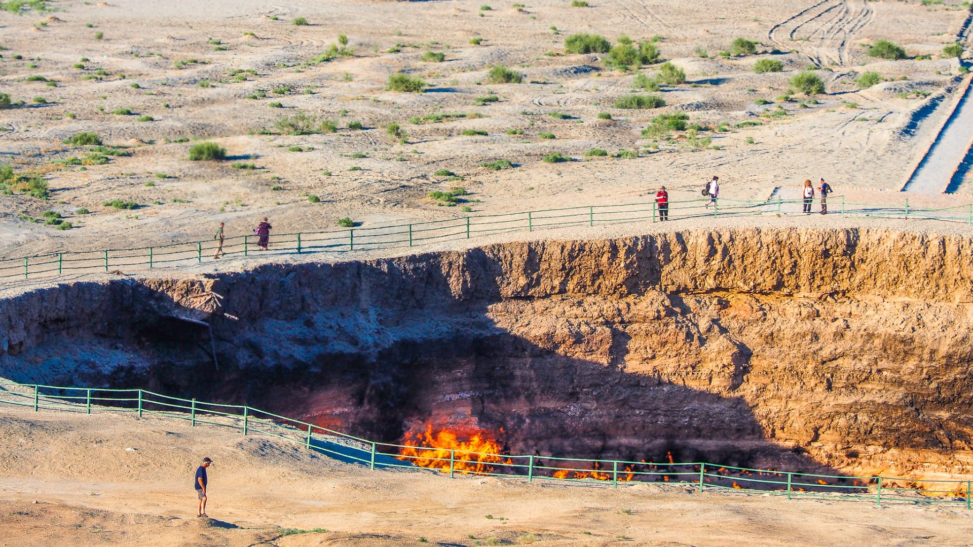
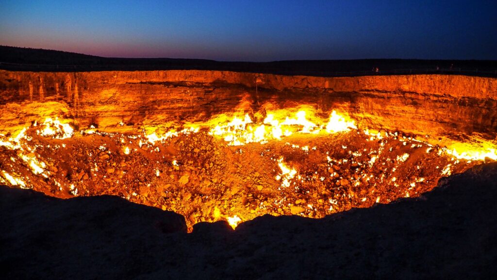
Widely known as the “Door to Hell,” it is reasonable to say this is one of the most remarkable phenomena in Turkmenistan. The fiery pit is located in the middle of the Karakum Desert and has been burning continuously since 1971. The crater was allegedly formed during a Soviet drilling operation when engineers accidentally drilled into a natural gas cavern, causing the ground to collapse and form a crater. To prevent the spread of methane gas, the engineers decided to set it on fire, expecting it to burn out in a few weeks. Over 50 years later, the crater is still burning, creating quite a spectacle. It is unclear, however, if this story is entirely true or not, as it has not been verified by any sort of evidence available to outsiders.
Throughout the years, the crater has released vast amounts of methane into the atmosphere, drawing attention from environmental scientists and researchers. Studies conducted at the site have provided insights into extremophiles—microorganisms that thrive in extreme conditions. In 2013, explorer George Kourounis descended into the crater to collect samples, discovering bacteria that could potentially survive on other planets.
To journey from Ashgabat to the Darvaza Gas Crater covers about 260 km (162 mi) and takes 3-4 hours by car. A 4×4 vehicle is likely the best option given the rough terrain, especially as you get closer to the crater. Along the way, you’ll pass through sparsely populated areas, giving you a glimpse of rural life in Turkmenistan.
Arriving at the Darvaza Gas Crater in the late afternoon allows ample time to set up camp and prepare for an evening of sights. The crater is approximately 70 m (230 ft) wide and 20 m (66 ft) deep, with flames constantly flickering along its edges. The heat and light from the burning gas create an eerie glow that can be seen from miles away, especially as the sun sets. Note that you need to set up the camp at a safe distance from the crater’s edge to avoid the intense heat and gas emissions.
As night falls, the true spectacle of the Darvaza Gas Crater comes to life. The flames, visible in the dark, provide a stark contrast to the star-filled sky above. This may well be one of the most surreal camping experiences in the world. That being said, the crater is also harmful to the environment, and is quite likely that it will not remain a tourist destination in its current form for much longer.
Darvaza Gas Crater at night. Do you find it pretty, scary, or both?
Day 3: Darvaza to Yangykala Canyon
Yangykala Canyon also has a nickname, namely the “Grand Canyon of Turkmenistan”. Located in the northwest part of Turkmenistan, near the Caspian Sea, the canyon is remarked by colorful rock formations, which range from deep reds and pinks to vibrant yellows and whites. These formations were created over millions of years by the erosion of sedimentary rock layers. The vibrant colors are due to the varying mineral content of the different rock layers, each representing a different period in geological time.
The journey from Darvaza to Yangykala Canyon is quite long but, for desert aficionados, rewarding. You will need around 8 hours for the approximately 500 km (311 mi) and may enjoy the views of flat desert terrain giving way to the towering cliffs and deep gorges of Yangykala.
The canyon walls, which can reach heights of up to 60 m (197 ft), are a kaleidoscope of colors, particularly striking at sunrise and sunset when the light enhances the hues of the rock layers. There are several viewpoints around the canyon that offer panoramic views, including the famous “Crocodile’s Mouth,” a rock formation that provides a unique perspective of the canyon below.
Camping at Yangykala Canyon is a pretty experience, as the remote location and lack of light pollution make it an ideal spot for stargazing. Setting up camp on the plateau above the canyon provides a perfect vantage point for both sunset and sunrise, allowing you to witness the changing colors of the canyon walls in the soft light.
Day 4: Yangykala Canyon to Melegoch
The Melegoch area, southeast of Yangykala Canyon, is the place to go if you want to explore ancient necropolises within a desert landscape. The burial sites, some dating back thousands of years, feature intricately carved tombstones and mausoleums. The drive from Yangykala Canyon to Melegoch is approximately 250 km (155 mi), taking about 4-5 hours. Upon arrival in Melegoch, you’ll likely notice rocky outcrops, vast open spaces, and the remains of ancient burial sites that dot the area.
Day 5: Melegoch to Karakum Lake and Damla Village
The trek from Melegoch to Karakum Lake covers approximately 100 km (62 mi), taking about 2-3 hours. The route takes you deeper into the Karakum Desert. Upon reaching Karakum Lake, you will find a rare oasis in the desert, providing what may feel like a refreshing break from the harsh environment. Karakum Lake is a small lake that provides a vital water source for the local wildlife and a chill spot for travelers to rest.
From here, you can go to the Damla Village, approximately 50 km (31 miles) mi. Damla is known for its semi-nomadic inhabitants who maintain traditional lifestyles passed down through generations. The village is rather secluded; many of the villagers trek miles to neighboring towns like Bekuri, on foot or carried on camels or horseback for supplies and services. It’s certainly an interesting place to see for those who want to get a better idea of how living in a desert environment with limited resources feels like.
Day 6: Damla Village to Murzechirla and Gonur Depe
The trek from Damla Village to Murzechirla is about 150 km (93 mi), taking about 3-4 hours. Murzechirla Village is another semi-nomadic settlement, where you can observe traditional desert lifestyles.
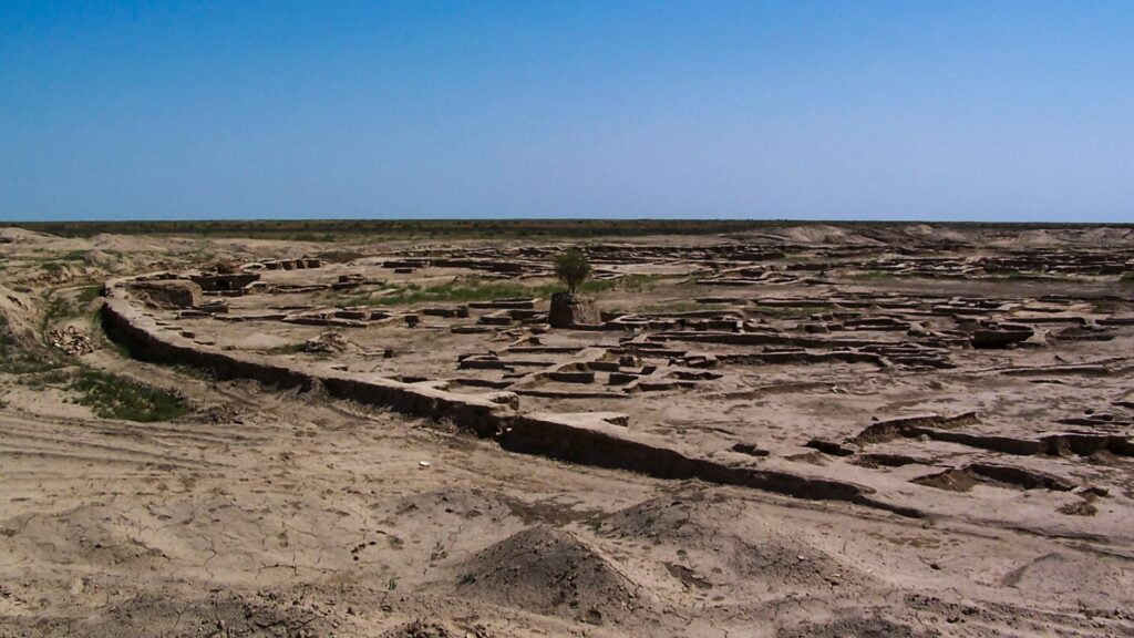
From Murzechirla, you can travel for an extra 50 km (31) to reach Gonur Depe – by far one of the most significant archaeological sites in Central Asia. This Bronze Age site is part of the ancient Margiana civilization, being an early human settlement in the region. The site is really interesting, as it features the remains of ancient buildings, including temples, palaces, and fortifications. In other words, it’s a true Bronze Age city!
Gonur Tepe as seen from a certain distance
Day 7: Gonur Depe to Mary and Ancient Merv
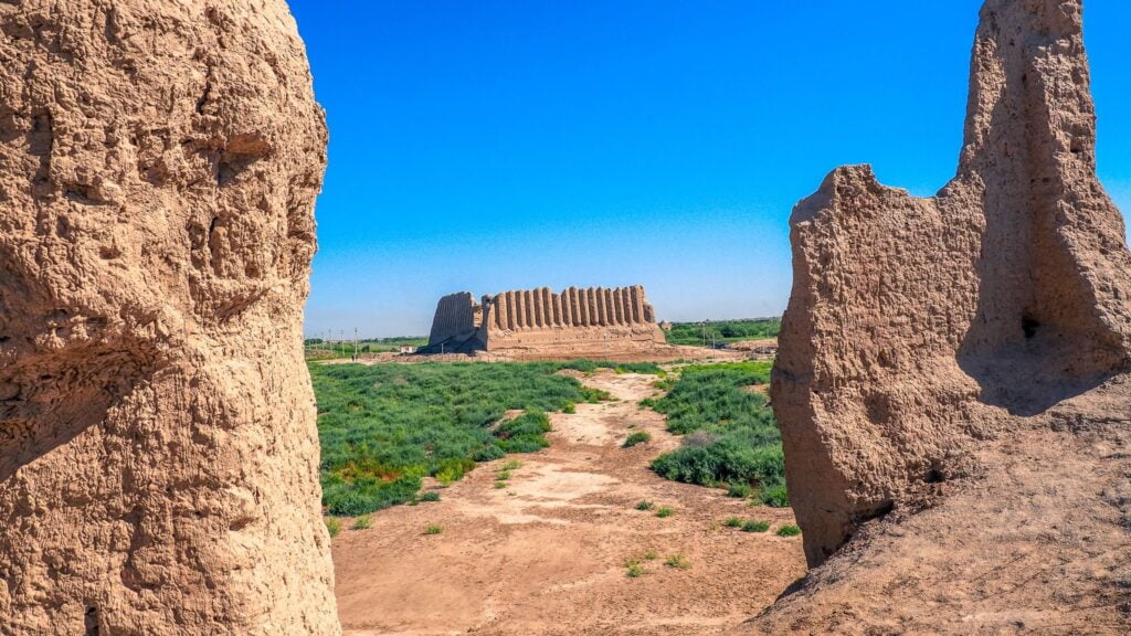
Time to travel another 100 km (62 mi) to reach Mary, a city that serves as the gateway to the ancient city of Merv, which is also a particularly important archaeological site in Central Asia. More specifically, Merv is a UNESCO World Heritage site and, at the same time, among the oldest and best-preserved Silk Road cities in Central Asia. The site consists of several walled cities, each representing different periods in the region’s history. The earliest remains date back to the Bronze Age, with subsequent layers reflecting the influence of various empires, including the Achaemenid, Parthian, Sassanian, and Islamic periods. Key attractions include the Mausoleum of Sultan Sanjar, the Great Kyz Kala fortress, and the ancient city walls.
Here’s Merv
Extra stop: Kunye Urgench
If you want to explore more of the country or consider heading to Uzbekistan on land, you should consider an extra stop in Kunye Urgench. Once a bustling center on the Silk Road, is now a UNESCO World Heritage Site known for its well-preserved architectural wonders and deep historical significance. The city, which flourished from the 10th to the 14th centuries, was a major cultural and commercial hub. It faced numerous invasions and natural calamities, but many of its monuments have survived
Consider starting your exploration of the site with the Kutlug Timur Minaret, which stands as the tallest minaret in Central Asia at nearly 60 m (196 ft). Built in the 11th century, this minaret is adorned with intricate brickwork and inscriptions an a pretty example of medieval Islamic architecture.
Next, visit the Mausoleum of Turabek Khanum, which was built in honor of a princess of the Golden Horde. The mausoleum’s interior is known for its stunning tile work and geometric patterns. The domed ceiling, with its complex designs, is particularly interesting.
The Mausoleum of Sultan Tekesh is another highlight. This structure commemorates Sultan Tekesh, one of the prominent rulers of the Khwarezmian Empire. The mausoleum’s large, ribbed dome and robust construction have stood the test of time, offering insights into pre-Mongol architecture. Nearby, you also have the Mausoleum of Il-Arslan, a building with a distinctive conical dome, the Najmuddin Kubra Mausoleum, and the Sultan Ali Mausoleum.
Best time to trek the Karakum Desert
Spring (March to June) is arguably the sweet spot for visiting the Karakum Desert. With temperatures ranging from 15 to 25 degrees Celsius (59 to 77 degrees Fahrenheit), the weather is mild. Spring rains bring the desert to life with blooming wildflowers, and cultural festivals like Nowruz and Ahalteke Horse Day add to the charm.
Autumn (October to December) is also a good time to visit, with temperatures between 12 and 23 degrees Celsius (54 to 73 degrees Fahrenheit). Summer (July to September) can be brutally hot, with temperatures often exceeding 40 degrees Celsius (104 degrees Fahrenheit). Winter (December to February) brings cold temperatures, sometimes around 0 degrees Celsius (32 degrees Fahrenheit).
A few things to know about Turkmenistan
Turkmenistan operates primarily on a cash economy. The official currency is the Turkmenistan Manat (TMT). While credit cards are accepted in major hotels and some shops in Ashgabat, cash is the way to go.
Turkmenistan is generally safe for tourists, crime-wise. However, in case you haven’t figured it out by now, it’s also a dictatorship. In fact, it is arguably one of the world’s craziest dictatorships but happens to get a lot less noticed compared to places like North Korea. That’s what happens when you can’t make threats with nukes.
The country’s rights record is dire, with severe restrictions on freedom of expression, assembly, and religion. Media is state-controlled, and access to independent information is severely limited. Internet censorship is rampant, with many sites and social media platforms blocked. The use of Virtual Private Networks (VPNs) is illegal, and those caught using them can face fines or imprisonment.
But as long as there’s no direct evidence that you traveling there represents financial or other type of support for the government, I see no reason why not explore the place and enjoy some of the cool stuff it has to offer, provided you are allowed to. Just keep in mind that the government closely monitors activities and by no means should you discuss political topics, both in public and online, to prevent unwanted attention from authorities.
Perhaps the worst thing about Turkmenistan from a tourist’s perspective is that you are unable to travel throughout the country without an accredited guide. It’s only in the capital that the guide does not have to be physically with you. Your only option is to choose a reputable travel agency that specializes in Turkmenistan. Agencies like Advantour can arrange comprehensive tours. Most agencies will handle the LOI required for your visa application. This letter is essential and must be approved before you can apply for a visa. Work with the agency to plan a customized itinerary that includes the sites you want to see, such as the Darvaza Gas Crater or the ancient city of Merv.
How to get to Turkmenistan
Flying to Turkmenistan is the most straightforward option. The main international gateway is Ashgabat International Airport (ASB), well-connected to major cities across Europe, Asia, and the Middle East. Airlines like Turkish Airlines, Lufthansa, and FlyDubai offer regular flights. Make sure to check visa requirements, as Turkmenistan has strict entry regulations.
Ready to trek one of the most isolated countries in the world?
Now you know quite a few things about the sprawling sands of the Karakum Desert and the fiery allure of the Darvaza Gas Crater. Do you already picture yourself navigating ancient caravan routes and snapping selfies with flaming gas craters and Bronze-age structures? Are you hyped about traveling to one of the world’s most isolated countries where much of a city is built of white marble?
It’s also worth mentioning that trekking the Karakum Desert can be part of your Silk Road itinerary, where you trace the steps of ancient caravans along the most famous commercial network. Once you have explored Turkmenistan, consider heading eastwards, towards Uzbekistan, and see places such as the Silk Road cities of Khiva, Bukhara, and Samarkand.

